
Make a donation
Paranaguá topographic map
Click on the map to display elevation.
Make a donation
Paranaguá
Paranaguá experiences a humid subtropical climate (Köppen: Cfa), next to northern limit of the category in the southern hemisphere (border of the coast of São Paulo/Paraná). The coastal location and the Brazil current molds a climate different from the usual one of the interior of the Paraná. The summers can be hot, mainly in the low altitudes and a little more interior. In warmer months, seemly the temperature is equal to or above 30 °C. The winter is very mild, in general it is as if it had only 3 seasons, when compared comparing with cities as Curitiba or Ponta Grossa with record temperatures of 5 °C lower. The central months of the year have temperatures averaging over 10 °C. Frost is not unknown, but is not expected in a normal winter. The updated normals give a value of precipitation above 2200 mm, which shows the rainy character of the city, although rain days are close to some drier climates. January to March are the wettest months with the advance of Atlantic tropical masses, and the months from June to August are the driest, due to the influence of the polar mass, but with relatively high precipitation. Sunshine hours are a bit low for the subtropics, being part of the effect of the large amount of water vapor on the airand the consequent cloudiness present.
Make a donation
About this map
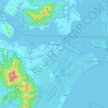
Name: Paranaguá topographic map, elevation, terrain.
Average elevation: 63 m
Minimum elevation: -3 m
Maximum elevation: 1,450 m
Make a donation
Other topographic maps
Click on a map to view its topography, its elevation and its terrain.