
Make a donation
Nuremberg topographic map
Click on the map to display elevation.
Make a donation
Nuremberg
Nuremberg has an oceanic climate (Köppen Cfb) with a certain humid continental influence (Dfb), categorized in the latter by the 0 °C isotherm. The city's climate is influenced by its inland position and higher altitude. Winters are changeable, with either mild or cold weather: the average temperature is around −3 °C (27 °F) to 4 °C (39 °F), while summers are generally warm, mostly around 13 °C (55 °F) at night to 25 °C (77 °F) in the afternoon. Precipitation is evenly spread throughout the year, although February and April tend to be a bit drier whereas July tends to have more rainfall.
Make a donation
About this map
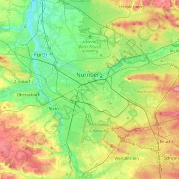
Name: Nuremberg topographic map, elevation, terrain.
Location: Nuremberg, Bavaria, Germany (49.33143 10.98873 49.54075 11.28260)
Average elevation: 336 m
Minimum elevation: 279 m
Maximum elevation: 437 m
Make a donation
Other topographic maps
Click on a map to view its topography, its elevation and its terrain.
Hochstaufen
Germany > Bavaria > Landkreis Berchtesgadener Land > Bad Reichenhall
At an altitude of 1,750 m is the Reichenhaller Haus, an alpine hut of the Deutscher Alpenverein (Section Bad Reichenhall).
Average elevation: 1,115 m
Make a donation
Make a donation
Pegnitz
Germany > Bavaria > Nürnberger Land > Hersbruck > Weiher
The Pegnitz has its source in the town of the same name at an altitude of 425 m (1,394 ft) and meets the Rednitz at 283 m (928 ft) in Fürth to form the Regnitz river. Shortly after the source, the Pegnitz unites with the 15 km (9.3 mi) long Fichtenohe while keeping the name of the shorter tributary. Some…
Average elevation: 357 m
Make a donation
Kellmünz an der Iller
Germany > Bavaria > Landkreis Neu-Ulm > Kellmünz a.d.Iller
Average elevation: 562 m
Make a donation
Zugspitze
Germany > Bavaria > Landkreis Garmisch-Partenkirchen > Grainau
The mountain rises eleven kilometres southwest of Garmisch-Partenkirchen and just under six kilometres east of Ehrwald. The border between Germany and Austria runs over the west summit; thus the Zugspitze massif belongs to the German state of Bavaria and the Austrian state of Tyrol. The municipalities…
Average elevation: 2,300 m