
Magallanes and Chilean Antarctica Region topographic map
Interactive map
Click on the map to display elevation.
Magallanes and Chilean Antarctica Region
The topography can be divided in four regions: an outer archipelago region (Spanish: Región Archipielágica) to the west and south, a mountain region in the west and south (Spanish: Región Cordillerana), a plains region (Spanish: Región de las Planicies Orientales) in the northeast plus a sub-Andean zone in-between the last two zones (Spanish: Región Sub-Andina Oriental).
About this map
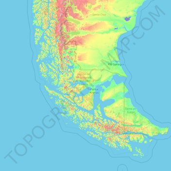
Name: Magallanes and Chilean Antarctica Region topographic map, elevation, terrain.
Location: Magallanes and Chilean Antarctica Region, Chile (-56.53830 -75.72252 -48.58223 -66.41599)
Average elevation: 126 m
Minimum elevation: -25 m
Maximum elevation: 3,310 m
Other topographic maps
Click on a map to view its topography, its elevation and its terrain.
Santiago
Chile > Santiago Metropolitan Region > Provincia de Santiago > Santiago
The city lies in the center of the Santiago Basin, a large bowl-shaped valley consisting of broad and fertile lands surrounded by mountains. The city has a varying elevation, gradually increasing from 400 m (1,312 ft) in the western areas to more than 700 m (2,297 ft) in the eastern areas. Santiago's…
Average elevation: 724 m
Atacama Desert
Chile > Antofagasta Region > Provincia de Antofagasta > Antofagasta
The Coastal Cliff of northern Chile west of the Chilean Coast Range is the main topographical feature of the coast. The geomorphology of the Atacama Desert has been characterized as a low-relief bench "similar to a giant uplifted terrace" by Armijo and co-workers. The intermediate depression (or Central…
Average elevation: 1,961 m
Punta Roa
Chile > Valparaiso Region > Easter Island Province > Easter Island > Hanga Roa
Average elevation: 11 m
Valle del Aconcagua
Chile > Valparaiso Region > Provincia de Quillota > Hijuelas > La Sombra
Average elevation: 349 m
Plaza de Armas
Chile > Coquimbo Region > Provincia de Limarí > Ovalle > Sotaquí
Average elevation: 290 m
Canal de Relave Codelco División El Teniente
Chile > Provincia de Cachapoal > Requínoa
Average elevation: 629 m
Parque Industrial Los Libertadores
Chile > Santiago Metropolitan Region > Provincia de Chacabuco > Colina
Average elevation: 520 m
Zona Central
Chile > Maule Region > Provincia de Curicó > Teno
The topography of central Chile includes a coastal range of mountains running parallel to the Andes. Lying between the two mountain ranges is the so-called Central Valley, which contains some of the richest agricultural land in the country, especially in its northern portion. The area just north and south of…
Average elevation: 1,121 m
Tupungato
Chile > Santiago Metropolitan Region > Provincia de Cordillera > San José de Maipo
Average elevation: 6,002 m
Cerro San Cristóbal
Chile > Santiago Metropolitan Region > Provincia de Santiago
The summit of Cerro San Cristóbal can be reached by foot (about a 45-minute walk, involving a 300m change in elevation), by car via the road joining the Santiago Metropolitan Park, by the Funicular de Santiago (the base of which sits next to the Zoo at the North end of Pio Nono in Barrio Bellavista), or by a…
Average elevation: 615 m
Isla Cabrera
Chile > Magallanes and Chilean Antarctica Region > Provincia de Última Esperanza
Average elevation: 80 m
Placilla de Peñuelas
Chile > Valparaiso Region > Provincia de Valparaíso > Valparaíso
Average elevation: 354 m
Puerto Río Tranquilo
Chile > Aysen del General Carlos Ibanez del Campo Region > Provincia de General Carrera > Río Ibáñez
Average elevation: 323 m
Guatín
Chile > Antofagasta Region > Provincia de El Loa > San Pedro de Atacama
Average elevation: 3,275 m
Tupungato
Chile > Santiago Metropolitan Region > Provincia de Cordillera > San José de Maipo
Average elevation: 6,002 m
Isla Florencia
Chile > Aysen del General Carlos Ibanez del Campo Region > Provincia de Aysén > Cisnes
Average elevation: 13 m
Laguna de los Cisnes
Chile > Magallanes and Chilean Antarctica Region > Provincia de Tierra del Fuego > Porvenir
Average elevation: 31 m
Volcán Ojos del Toro
Chile > Antofagasta Region > Provincia de El Loa > San Pedro de Atacama
Average elevation: 5,503 m
A018
Chile > Antofagasta Region > Provincia de El Loa > San Pedro de Atacama > Atacama Large Millimeter/submillimeter Array
Average elevation: 5,021 m
Mendoza
Chile > Arica y Parinacota Region > Provincia de Parinacota > Putre
Average elevation: 3,642 m
Condominio San José
Chile > O'Higgins Region > Provincia de Cachapoal > Requínoa
Average elevation: 420 m
Clear water
Chile > Aysen del General Carlos Ibanez del Campo Region > Provincia de Capitán Prat > O’Higgins
Average elevation: 399 m
Cerro Alvarado
Chile > Santiago Metropolitan Region > Provincia de Cordillera > San José de Maipo
Average elevation: 3,937 m
Laguna Lejía
Chile > Antofagasta Region > Provincia de El Loa > San Pedro de Atacama
Lejía Lake is a circular, shallow lake at an elevation of 4,325 metres (14,190 ft) with a surface area of 1.9 square kilometres (0.73 sq mi) or 2 square kilometres (0.77 sq mi). It is a polymictic lake which freezes over occasionally and whose waters are turned over quickly, mainly through evaporation. Winds…
Average elevation: 4,341 m
El Cobre
Chile > Valparaiso Region > Provincia de San Felipe de Aconcagua > Catemu
Average elevation: 547 m
Cerro Torre
Chile > Magallanes and Chilean Antarctica Region > Provincia de Última Esperanza > Puerto Natales
Average elevation: 1,916 m
Parinacota
Chile > Arica y Parinacota Region > Provincia de Parinacota > Putre
It is situated on the highlands at an elevation of 4,400 metres (14,400 ft) in Lauca National Park near the small town of Putre and had 29 inhabitants as of 2002.
Average elevation: 4,462 m
Cerro Ballena
Chile > Region of Magallanes and Chilean Antarctica > Provincia de Última Esperanza > Puerto Natales
Average elevation: 400 m
Santuario de la Naturaleza y RENAMU Humedal Desembocadura Río Lluta
Chile > Arica and Parinacota Region > Provincia de Arica > Arica > Villa Frontera > Las Machas
Average elevation: 10 m
Bien Nacional Protegido Yacimiento Paleontológico Cerro Ballena
Chile > Atacama Region > Provincia de Copiapó > Caldera
Average elevation: 53 m
Serrano Glacier
Chile > Region of Magallanes and Chilean Antarctica > Provincia de Última Esperanza > Torres del Paine
Average elevation: 289 m
Termas del Flaco
Chile > O'Higgins Region > Provincia de Colchagua > San Fernando
Average elevation: 2,033 m
Lookout at Mount Fitzroy
Chile > Aysén Region > Provincia de Capitán Prat > O’Higgins
Average elevation: 657 m
Punta de Tralca
Chile > Valparaiso Region > Provincia de San Antonio > El Quisco
Average elevation: 44 m
Cape Horn
Chile > Region of Magallanes and Chilean Antarctica > Provincia de la Antártica Chilena > Cape Horn
Average elevation: 40 m
Peldehue
Chile > Santiago Metropolitan Region > Provincia de Chacabuco > Colina
Average elevation: 743 m
Parque Tricao
Chile > Valparaiso Region > Provincia de San Antonio > Santo Domingo
Average elevation: 76 m
Aeropuerto
Chile > Region of Magallanes and Chilean Antarctica > Provincia de Magallanes > Punta Arenas
Average elevation: 21 m
Cerro Tórtolas
Chile > Santiago Metropolitan Region > Provincia de Cordillera > San José de Maipo
Average elevation: 3,636 m
Cerro Las Tórtolas
Chile > Coquimbo Region > Provincia de Elqui > Vicuña
Cerro Las Tórtolas is a peak at the border of Argentina and Chile with an elevation of 6,145 metres (20,161 ft) metres and located at the Central Andes. It is on the border of the Argentinean province of San Juan and Chilean province of Elqui. Its slopes are within the administrative boundaries of Argentinean…
Average elevation: 5,610 m
Atacama Desert
Chile > Antofagasta Region > Provincia de Antofagasta > Antofagasta
The Coastal Cliff of northern Chile west of the Chilean Coast Range is the main topographical feature of the coast. The geomorphology of the Atacama Desert has been characterized as a low-relief bench "similar to a giant uplifted terrace" by Armijo and co-workers. The intermediate depression (or Central…
Average elevation: 1,961 m