
Lai Châu Province topographic map
Interactive map
Click on the map to display elevation.
About this map
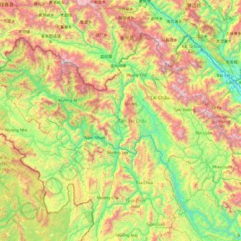
Name: Lai Châu Province topographic map, elevation, terrain.
Location: Lai Châu Province, Vietnam (21.68608 102.32053 22.81393 103.98584)
Average elevation: 1,009 m
Minimum elevation: 94 m
Maximum elevation: 3,056 m
Other topographic maps
Click on a map to view its topography, its elevation and its terrain.
Lang Biang Mountain
Vietnam > Lâm Đồng Province > Lạc Dương District > Lạc Dương
Average elevation: 1,786 m
Ban Gioc (Detian) waterfall
Vietnam > Cao Bằng Province > Trùng Khánh District
Average elevation: 493 m