
Thank you for supporting this site ❤️
Make a donation
Make a donation
Aalen topographic map
Click on the map to display elevation.
Thank you for supporting this site ❤️
Make a donation
Make a donation
Aalen
The elevation in the centre of the market square is 430 m (1,410 ft) relative to Normalhöhennull. The territory's lowest point is at the Lein river near Rodamsdörfle, the highest point is the Grünberg's peak near Unterkochen at 733 m (2,405 ft).
Thank you for supporting this site ❤️
Make a donation
Make a donation
About this map
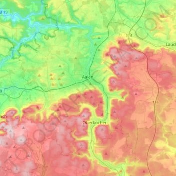
Name: Aalen topographic map, elevation, terrain.
Average elevation: 554 m
Minimum elevation: 359 m
Maximum elevation: 771 m
Thank you for supporting this site ❤️
Make a donation
Make a donation