
Thank you for supporting this site ❤️
Make a donation
Make a donation
Campos do Jordão topographic map
Click on the map to display elevation.
Thank you for supporting this site ❤️
Make a donation
Make a donation
Campos do Jordão
The city's economy is based mainly on tourism; due to its location at high elevation in the Mantiqueira Mountains, and traditional European-style architecture. Buildings are mostly vernacular architecture from German, Swiss, or Italian models. Many of the wealthiest residents in the state of São Paulo have winter country houses here.
Thank you for supporting this site ❤️
Make a donation
Make a donation
About this map
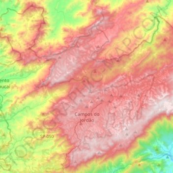
Name: Campos do Jordão topographic map, elevation, terrain.
Average elevation: 1,358 m
Minimum elevation: 598 m
Maximum elevation: 1,954 m
Thank you for supporting this site ❤️
Make a donation
Make a donation