
Make a donation
Prunedale topographic map
Click on the map to display elevation.
Make a donation
Prunedale
Prunedale is a census-designated place in Monterey County, California, United States. It is located 8 miles (13 km) north of Salinas at an elevation of 92 feet (28 m). The population was 18,885 as of the 2020 census, up from 17,560 in 2010. Plum trees were grown in Prunedale in the early days of its founding, but the trees died soon after due to poor irrigation and fertilizer.
Make a donation
About this map
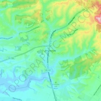
Name: Prunedale topographic map, elevation, terrain.
Average elevation: 69 m
Minimum elevation: -8 m
Maximum elevation: 275 m
Make a donation
Other topographic maps
Click on a map to view its topography, its elevation and its terrain.
Monterey
United States > California > Monterey County
During winter, snow occasionally falls in the higher elevations of the Santa Lucia Mountains and Gabilan Mountains that overlook Monterey, but snow in Monterey itself is extremely rare. A few unusual events in January 1962, February 1976, and December 1997 brought a light coating of snow to Monterey. In March…
Average elevation: 50 m