
Make a donation
Arteaga topographic map
Click on the map to display elevation.
Make a donation
About this map
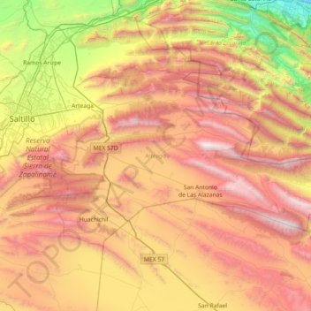
Name: Arteaga topographic map, elevation, terrain.
Location: Arteaga, Coahuila, Mexico (25.15326 -100.95120 25.53584 -100.22958)
Average elevation: 2,066 m
Minimum elevation: 549 m
Maximum elevation: 3,709 m
Make a donation
Other topographic maps
Click on a map to view its topography, its elevation and its terrain.
Ramos Arizpe
Mexico > Coahuila > Ramos Arizpe
Ramos Arizpe has a desert climate (Köppen climate classification BWh Owing to its altitude of 1,400 to 1,500 m (4,600 to 4,900 ft) above sea level, temperatures are milder than other desert cities at lower elevations. Winters are mild with warm temperatures during the day and cold nights. The January average…
Average elevation: 1,426 m
Saltillo
El Cerro del Pueblo (The People's Hill) and its 4-metre (13 ft) cross overlook the city. The city's elevation makes it colder and windier than the neighboring city of Monterrey. Saltillo lies in the Chihuahuan Desert near the city of Arteaga. The city is flanked by the Zapalinamé mountains, which are part of…
Average elevation: 1,857 m
Ramos Arizpe
Mexico > Coahuila > Ramos Arizpe
Ramos Arizpe has a desert climate (Köppen climate classification BWh Owing to its altitude of 1,400 to 1,500 m (4,600 to 4,900 ft) above sea level, temperatures are milder than other desert cities at lower elevations. Winters are mild with warm temperatures during the day and cold nights. The January average…
Average elevation: 1,426 m
Make a donation
Saltillo
El Cerro del Pueblo (The Town Hill) and its 4-metre (13 ft) cross overlook the city. The city's elevation makes it colder and windier than the neighboring city of Monterrey. Saltillo lies in the Chihuahuan Desert near the city of Arteaga. The city is flanked by the Zapalinamé mountains, which are part of the…
Average elevation: 1,857 m
Make a donation
Ejido Santo Tomas
Mexico > Coahuila > Matamoros > Colonia Enrique Martinez y Martinez
Average elevation: 1,116 m
Make a donation
Piedras Negras
Mexico > Coahuila > Municipio de Piedras Negras > Piedras Negras
Average elevation: 256 m
Make a donation
Saltillo
El Cerro del Pueblo (The Town Hill) and its 4-metre (13 ft) cross overlook the city. The city's elevation makes it colder and windier than the neighboring city of Monterrey. Saltillo lies in the Chihuahuan Desert near the city of Arteaga. The city is flanked by the Zapalinamé mountains, which are part of the…
Average elevation: 1,857 m