
Make a donation
Roseville topographic map
Click on the map to display elevation.
Make a donation
Roseville
The wet season is generally October through April. Because Roseville is east of Sacramento and at a higher elevation, it receives slightly more rainfall. The dry season lasts from June to October; similar to other Central Valley cities, temperatures can be extremely hot in the summer (routinely peaking above 105 °F (41 °C) on the hottest days), unusual for a non-desert climate at mid-latitude. For any given year, summers can be consistently hot or mild depending on where the position of the North Pacific High settles around the end of June. Extremely hot years with July highs typically around 100 °F (38 °C) are averaged out against milder summers that reach around 90 °F (32 °C).
Make a donation
About this map
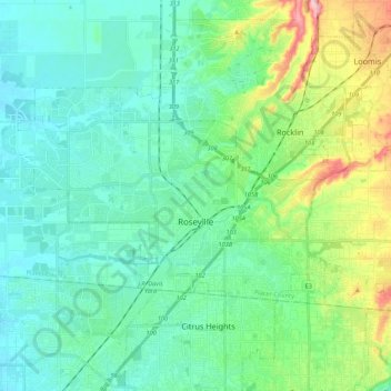
Name: Roseville topographic map, elevation, terrain.
Location: Roseville, Placer County, California, United States (38.71635 -121.44670 38.82435 -121.18416)
Average elevation: 67 m
Minimum elevation: 17 m
Maximum elevation: 290 m
Make a donation
Other topographic maps
Click on a map to view its topography, its elevation and its terrain.
Make a donation
Make a donation
Make a donation
Make a donation
Make a donation
Carnelian Bay
United States > California > Placer County
For statistical purposes, the United States Census Bureau has defined Carnelian Bay as a census-designated place (CDP). The census definition of the area may not precisely correspond to local understanding of the area with the same name. The population was 524 at the 2010 census. The elevation is 6,325 feet…
Average elevation: 1,977 m
Make a donation
Make a donation
Make a donation
Make a donation
Make a donation
Blue Canyon
United States > California > Placer County
Blue Canyon (also, Blue Cañon) is an unincorporated community in Placer County, California. Blue Canyon is located 4 miles (6.4 km) southwest of Emigrant Gap. It lies at an elevation of 4695 feet (1431 m).
Average elevation: 1,452 m