
Thank you for supporting this site ❤️
Make a donation
Make a donation
Kluang topographic map
Click on the map to display elevation.
Thank you for supporting this site ❤️
Make a donation
Make a donation
About this map
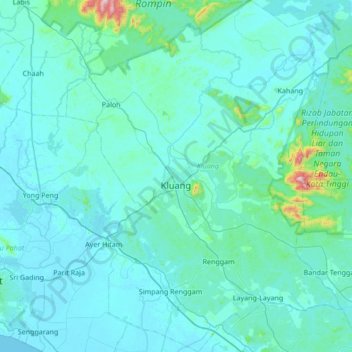
Name: Kluang topographic map, elevation, terrain.
Location: Kluang, Johor, Malaysia (1.70962 103.10652 2.38928 103.64178)
Average elevation: 54 m
Minimum elevation: 0 m
Maximum elevation: 965 m
Thank you for supporting this site ❤️
Make a donation
Make a donation
Other topographic maps
Click on a map to view its topography, its elevation and its terrain.