
Thank you for supporting this site ❤️
Make a donation
Make a donation
Aral City topographic map
Click on the map to display elevation.
Thank you for supporting this site ❤️
Make a donation
Make a donation
About this map
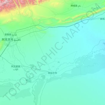
Name: Aral City topographic map, elevation, terrain.
Location: Aral City, Xinjiang, 843300, China (40.28935 79.38463 41.54822 81.97661)
Average elevation: 1,212 m
Minimum elevation: 970 m
Maximum elevation: 6,186 m
Thank you for supporting this site ❤️
Make a donation
Make a donation
Other topographic maps
Click on a map to view its topography, its elevation and its terrain.
Turpan Depression
China > Xinjiang > Gaochang District
The Turpan Basin formed in a shear zone during the Late Permian due to motion between the East European and the Angaran craton. It was subsequently deformed by the collision of the Indian and Eurasian plates in the Cenozoic. In the latter deformation, a thrust fault belt running from east to west, the Flaming…
Average elevation: -152 m