Geolocate

Киргизский хребет topographic map

Interactive map

Click on the map to display elevation.

Киргизский хребет topographic map, elevation, terrain

Киргизский хребет topographic map, elevation, terrain

About this map

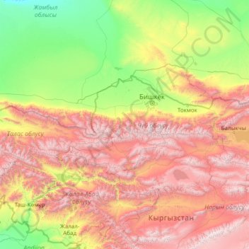
Name: Киргизский хребет topographic map, elevation, terrain.

Location: Киргизский хребет, 722121, Kyrgyzstan (42.18783 71.50314 42.94838 76.34948)

Average elevation: 1,645 m

Minimum elevation: 326 m

Maximum elevation: 4,686 m

Other topographic maps

Click on a map to view its topography, its elevation and its terrain.

Talas Region

Kyrgyzstan

Average elevation: 1,727 m

Naryn City

Kyrgyzstan > Naryn Region

Average elevation: 2,420 m

Tyup

Kyrgyzstan > Issyk-Kul Region > Tüp District

Average elevation: 1,625 m

Kochkor River

Kyrgyzstan > Naryn Region

Average elevation: 1,888 m

Chatkal ridge

Kyrgyzstan > Jalal-Abad Region

Average elevation: 2,463 m

Chuy

Kyrgyzstan > Chuy Region > Chuy

Average elevation: 822 m

Ak-suu

Kyrgyzstan > Batken Region

Average elevation: 3,318 m

Chu River

Kyrgyzstan > Issyk-Kul Region

Average elevation: 1,835 m

Ala-Kul Lake

Kyrgyzstan > Issyk-Kul Region > Karakol

Average elevation: 3,701 m

Кара-Суу

Kyrgyzstan > Naryn Region

Average elevation: 2,095 m

Ysyk-Ata River

Kyrgyzstan > Chuy Region

Average elevation: 691 m