
Thank you for supporting this site ❤️
Make a donation
Make a donation
Dunblane topographic map
Click on the map to display elevation.
Thank you for supporting this site ❤️
Make a donation
Make a donation
About this map
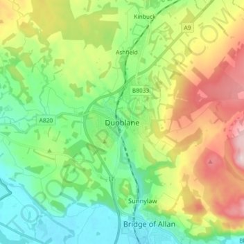
Name: Dunblane topographic map, elevation, terrain.
Location: Dunblane, Stirling, Scotland, FK15 0AY, United Kingdom (56.14831 -4.00409 56.22831 -3.92409)
Average elevation: 117 m
Minimum elevation: 3 m
Maximum elevation: 328 m
Thank you for supporting this site ❤️
Make a donation
Make a donation
Other topographic maps
Click on a map to view its topography, its elevation and its terrain.