
Jerusalem topographic map
Click on the map to display elevation.
Jerusalem
Jerusalem occupies a rugged hilltop setting on a rocky spur within the Judaean Mountains, where the urban landscape rises around about 2,575 feet (785 m) above sea level and is shaped by a compact pattern of limestone ridges, saddles, slopes, and deeply incised dry valleys. The Old City and surrounding districts stand above the Kidron, Hinnom, and Tyropoeon valleys, while Mount Scopus and the Mount of Olives form prominent high ground to the north and east, reinforcing the city’s strongly dissected relief. Westward, the terrain continues into the hilly Judean uplands, whereas eastward it descends abruptly toward the arid Judean Desert and the Dead Sea basin, giving Jerusalem a marked physical contrast between elevated Mediterranean highland terrain and steep desert-facing escarpments.
About this map
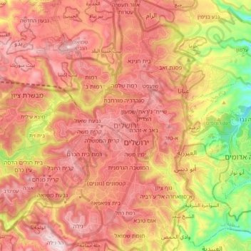
Name: Jerusalem topographic map, elevation, terrain.
Average elevation: 661 m
Minimum elevation: 264 m
Maximum elevation: 921 m
Other topographic maps
Click on a map to view its topography, its elevation and its terrain.
Jerusalem
Jerusalem is situated on the southern spur of a plateau in the Judaean Mountains, which include the Mount of Olives (East) and Mount Scopus (North East). The elevation of the Old City is approximately 760 m (2,490 ft). The whole of Jerusalem is surrounded by valleys and dry riverbeds (wadis). The Kidron,…
Average elevation: 520 m
Zecharya
Israel > Jerusalem District > Mate Yehuda Regional Council
The Tell rests upon a high hilltop, whereas the village lay on a slightly elevated part of the valley below, on the northwest side of the hill. The hill rises to a maximum elevation of 372 meters above sea level, with a mean elevation of approximately 275 meters above sea level. The village lay next to the…
Average elevation: 278 m