
Cimahi City topographic map
Click on the map to display elevation.
Cimahi City
Cimahi, located 180 km south east of Jakarta, is situated between Bandung and West Bandung Regency. Cimahi comprises three districts (kecamatan), which in turn are sub-divided into fifteen urban villages (kelurahan). Its lowest elevation is 685 metres (2,247 ft) above sea level and directs to Citarum River. Its highest elevation is 1,040 metres (3,410 ft) above sea level, which is part of the slope of mount Tangkuban Perahu and Burangrang. The Cimahi River flows through the city and Cimahi also has two Springs, named Cikuda and Cisontok.
About this map
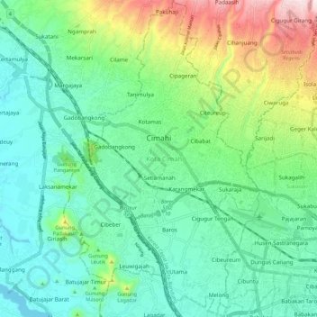
Name: Cimahi City topographic map, elevation, terrain.
Location: Cimahi City, West Java, Java, Indonesia (-6.93286 107.51032 -6.82735 107.57613)
Average elevation: 779 m
Minimum elevation: 633 m
Maximum elevation: 1,180 m
Other topographic maps
Click on a map to view its topography, its elevation and its terrain.