
Make a donation
Nabua topographic map
Click on the map to display elevation.
Make a donation
Nabua
Nabua has about 8,803.0600 hectares or 99.42% very low elevation or less than 100 meters elevation and remaining 51.3593 hectares or 0.58% of low elevation or between 100 and 300 meters elevation. Its slope covers about 7,927.3616 hectares or 89.53% which are level to nearly level (0-3%) while the remaining 927.0577 hectares or 10.47% are rolling to moderately steep (18-30%)
Make a donation
About this map
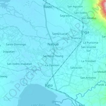
Name: Nabua topographic map, elevation, terrain.
Location: Nabua, Camarines Sur, Bicol Region, Philippines (13.36372 123.29051 13.42938 123.42290)
Average elevation: 27 m
Minimum elevation: 2 m
Maximum elevation: 623 m
Make a donation
Other topographic maps
Click on a map to view its topography, its elevation and its terrain.
Make a donation
Make a donation
Make a donation
Buhi
Buhi has generally mountainous and hilly surface, with 50% of its area having a slope of around 25%. The Poblacion located on the south shore of Lake Buhi, has gently rolling topography.
Average elevation: 161 m
Make a donation
Mount Isarog
Philippines > Camarines Sur > Lugsad
Mount Isarog is an active stratovolcano located in the province of Camarines Sur, Philippines, on the island of Luzon. The mountain has active fumaroles and hot springs. It has an elevation of 2,011.6 m (6,600 ft) above mean sea level.
Average elevation: 671 m
Make a donation
Make a donation
Make a donation
Make a donation
Make a donation
Make a donation