
Thank you for supporting this site ❤️
Make a donation
Make a donation
Keller topographic map
Click on the map to display elevation.
Thank you for supporting this site ❤️
Make a donation
Make a donation
About this map
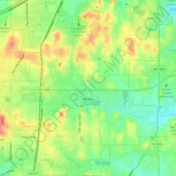
Name: Keller topographic map, elevation, terrain.
Location: Keller, Tarrant County, Texas, 76248, United States (32.89237 -97.26615 32.97857 -97.17680)
Average elevation: 213 m
Minimum elevation: 183 m
Maximum elevation: 252 m
Thank you for supporting this site ❤️
Make a donation
Make a donation
Other topographic maps
Click on a map to view its topography, its elevation and its terrain.