
Kalasin Province topographic map
Interactive map
Click on the map to display elevation.
Kalasin Province
Most of the province is covered by a hilly landscape. The town of Kalasin is at an elevation of 152 m (499 ft). In the north is the Lam Pao Dam built from 1963 to 1968. It stores 1,430 million m3 of water for flood prevention and agriculture. The Lam Pao reservoir effectively cuts the northern part of the province in half, but there are car ferries connecting the district of Sahatsakhan in the east with the district Nong Kung Si in the west, saving up to one hour off the journey by road. On the northwestern creek of the reservoir, a road bridge connects the village of Ban Dong Bang in the west with the district town of Wang Sam Mo in the east. Although the bridge was constructed several years ago (pre-2000), it is not featured (2006) on any commercially available road maps. Kalasin is known for the dinosaur fossils found at Phu Kum Khao (Sahatsakhan District), the largest dinosaur site in Thailand. Most of the fossils are sauropods from 120 million years ago.
About this map
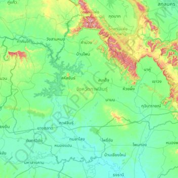
Name: Kalasin Province topographic map, elevation, terrain.
Location: Kalasin Province, Thailand (16.18175 103.09680 17.10111 104.24609)
Average elevation: 200 m
Minimum elevation: 128 m
Maximum elevation: 648 m
Other topographic maps
Click on a map to view its topography, its elevation and its terrain.
Chiang Mai
The city is situated in a valley on a river basin in the Thai highlands and is on average at 300 m (1,000 ft) elevation. Chiang Mai's city centre sits west of the Ping River, a tributary to the Chao Phraya River, while the city's sprawl extends north-west, south-west, north-east and east of the river. To the…
Average elevation: 424 m
Ban Ton Pho
Thailand > Pathum Thani Province > Suan Phrik Thai Subdistrict Administrative Organization > Suan Phrik Thai Subdistrict
Average elevation: 4 m
Ban Yai Ka Ta
Thailand > Phra Nakhon Si Ayutthaya Province > Uthai Subdistrict Administrative Organization > Uthai Subdistrict
Average elevation: 4 m
Bangkok
Bangkok is situated in the Chao Phraya River delta in Thailand's central plain. The river meanders through the city in a southerly direction, emptying into the Gulf of Thailand approximately 25 kilometres (16 mi) south of city centre. The area is flat and low-lying, with an average elevation of 1.5 metres (4…
Average elevation: 4 m
Ban Lak Khon Nuea
Thailand > Nonthaburi Province > Bang Bua Thong District > Lam Pho Subdistrict > Ban Lak Khon Nuea
Average elevation: 3 m