
Thank you for supporting this site ❤️
Make a donation
Make a donation
Garut topographic map
Click on the map to display elevation.
Thank you for supporting this site ❤️
Make a donation
Make a donation
Garut
The Garut Regency has two distinct topographical areas.
Thank you for supporting this site ❤️
Make a donation
Make a donation
About this map
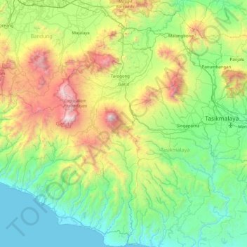
Name: Garut topographic map, elevation, terrain.
Location: Garut, West Java, Java, Indonesia (-7.74006 107.42028 -6.94570 108.13635)
Average elevation: 708 m
Minimum elevation: 0 m
Maximum elevation: 2,733 m
Thank you for supporting this site ❤️
Make a donation
Make a donation
Other topographic maps
Click on a map to view its topography, its elevation and its terrain.