Geolocate

Seseña topographic map

Click on the map to display elevation.

Seseña

La localidad se encuentra a una altitud de 598 m. La latitud es 40º 06' N y la longitud de 003º 42' O. Se ubica a 36 km del centro de Madrid. Está situado junto a los municipios madrileños de Valdemoro, Ciempozuelos y Aranjuez, y los toledanos de Esquivias y Borox. Pertenece a la comarca de La Sagra.

Wikipedia (CC-BY-SA 3.0)

About this map

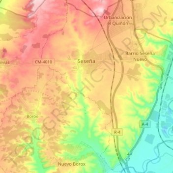
Name: Seseña topographic map, elevation, terrain.

Location: Seseña, Toledo, Castilla-La Mancha, España (40.03367 -3.73378 40.14329 -3.60390)

Average elevation: 595 m

Minimum elevation: 474 m

Maximum elevation: 714 m

Other topographic maps

Click on a map to view its topography, its elevation and its terrain.

Cobatilla

España > Castilla-La Mancha > Corduente > Aragoncillo

Average elevation: 1,266 m

Covatilla

España > Castilla-La Mancha > Cuenca

Average elevation: 984 m

Pico Padrón

España > Castilla-La Mancha > Bienservida

Average elevation: 1,376 m

Tiñosa

España > Castilla-La Mancha > Cantalojas

Average elevation: 1,717 m

Tajuña

España > Castilla-La Mancha > Maranchón

Average elevation: 1,269 m

Cedena

España > Castilla-La Mancha > Los Navalucillos

Average elevation: 1,083 m

Torcón

España > Castilla-La Mancha > Menasalbas

Average elevation: 741 m

Laguna de Uña

España > Castilla-La Mancha > Uña

Average elevation: 1,231 m

La Toja

España > Castilla-La Mancha > Villarrubio

Average elevation: 814 m

Cerro de la Mina

España > Castilla-La Mancha > Tortuero

Average elevation: 949 m

La Nava

España > Castilla-La Mancha > Jadraque

Average elevation: 1,029 m

Hoya del Portillo

España > Castilla-La Mancha > Talayuelas

Average elevation: 1,036 m

Agramón

España > Castilla-La Mancha > Hellín

Average elevation: 423 m

El Chaparral

España > Castilla-La Mancha > Pioz

Average elevation: 871 m

Cascada

España > Castilla-La Mancha > Mantiel

Average elevation: 910 m

Nava de Arriba

España > Castilla-La Mancha > Pozohondo

Average elevation: 874 m

Zulema

España > Castilla-La Mancha > Alcalá del Júcar

Average elevation: 687 m

Río Sorbe

España > Castilla-La Mancha > Humanes

Average elevation: 842 m

Cerro Concha

España > Castilla-La Mancha > Tortuero

Average elevation: 1,506 m

Caraquiz

España > Castilla-La Mancha

Average elevation: 713 m

El Establo

España > Castilla-La Mancha > Abenójar

Average elevation: 620 m

Huertos de Moya

España > Castilla-La Mancha

Average elevation: 1,038 m

Cerro

España > Castilla-La Mancha > Fuentealbilla > Bormate

Average elevation: 660 m

Argamasón

España > Castilla-La Mancha > Albacete

Average elevation: 756 m

La Pared

España > Castilla-La Mancha > Balsa de Ves

Average elevation: 724 m

Plañel

España > Castilla-La Mancha > Yeste

Average elevation: 884 m

El Sahuco

España > Castilla-La Mancha > Atienza

Average elevation: 1,142 m

Campillejo

España > Castilla-La Mancha > Campillo de Ranas

Average elevation: 1,123 m

El Conillo

España > Castilla-La Mancha > Cuenca

Average elevation: 1,609 m

Góntar

España > Castilla-La Mancha > Yeste

Average elevation: 1,078 m

Sierra

España > Castilla-La Mancha > Tobarra

Average elevation: 588 m

La Cabrera

España > Castilla-La Mancha > Sigüenza

Average elevation: 1,041 m

La Pollata

España > Castilla-La Mancha > Ocentejo

Average elevation: 1,064 m

La Alcarria

España > Castilla-La Mancha > Bujalaro

Average elevation: 994 m

El Chaparral

España > Castilla-La Mancha > Pioz

Average elevation: 871 m

Las Suertes

España > Castilla-La Mancha > Pioz

Average elevation: 868 m

La Zarza

España > Castilla-La Mancha > Pozuelo

Average elevation: 931 m

Pelegrina

España > Castilla-La Mancha > Sigüenza

Average elevation: 1,078 m

Cabeza Grande

España > Castilla-La Mancha > Cantalojas

Average elevation: 1,479 m

Cancarix

España > Castilla-La Mancha > Hellín

Average elevation: 497 m

Tortonda

España > Castilla-La Mancha > Alcolea del Pinar

Average elevation: 1,115 m

Alto del Hornillo

España > Castilla-La Mancha > Cantalojas

Average elevation: 1,597 m

Cantoblanco

España > Castilla-La Mancha > Balsa de Ves

Average elevation: 688 m

Olmedillas

España > Castilla-La Mancha > Sigüenza

Average elevation: 1,175 m

Guajaraz

España > Castilla-La Mancha > Argés

Average elevation: 605 m

Las Tinadas

España > Castilla-La Mancha > Tomelloso

Average elevation: 712 m

Pelegrina

España > Castilla-La Mancha > Sigüenza

Average elevation: 1,078 m

Castillo de Moya

España > Castilla-La Mancha > El Arrabal

Average elevation: 1,043 m

Nohales

España > Castilla-La Mancha > Cuenca

Average elevation: 946 m

Mesones

España > Castilla-La Mancha

Average elevation: 843 m

Cueva del Armentero

España > Castilla-La Mancha > Beteta

Average elevation: 1,178 m

Balconete

España > Castilla-La Mancha > Brihuega

Average elevation: 957 m

Ruguilla

España > Castilla-La Mancha > Cifuentes

Average elevation: 900 m

Manzaneruela

España > Castilla-La Mancha > Landete

Average elevation: 1,057 m

La Yunquera

España > Castilla-La Mancha > Lezuza

Average elevation: 821 m

Cuerda de la Melera

España > Castilla-La Mancha > Yeste

Average elevation: 964 m