
Thank you for supporting this site ❤️
Make a donation
Make a donation
Rothesay topographic map
Click on the map to display elevation.
Thank you for supporting this site ❤️
Make a donation
Make a donation
About this map
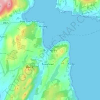
Name: Rothesay topographic map, elevation, terrain.
Location: Rothesay, Argyll and Bute, Scotland, PA20 9DQ, United Kingdom (55.79731 -5.09224 55.87731 -5.01224)
Average elevation: 38 m
Minimum elevation: -1 m
Maximum elevation: 262 m
Thank you for supporting this site ❤️
Make a donation
Make a donation
Other topographic maps
Click on a map to view its topography, its elevation and its terrain.