
Thank you for supporting this site ❤️
Make a donation
Make a donation
Slocan topographic map
Click on the map to display elevation.
Thank you for supporting this site ❤️
Make a donation
Make a donation
About this map
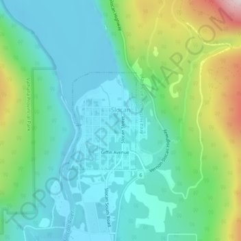
Name: Slocan topographic map, elevation, terrain.
Average elevation: 665 m
Minimum elevation: 532 m
Maximum elevation: 1,050 m
Thank you for supporting this site ❤️
Make a donation
Make a donation
Other topographic maps
Click on a map to view its topography, its elevation and its terrain.
Stoney Creek
Canada > British Columbia > Regional District of Central Kootenay > Area K (The Arrow Lakes)
Average elevation: 1,295 m
Appledale
Canada > British Columbia > Regional District of Central Kootenay > Area H (The Slocan Valley)
Average elevation: 707 m
Nelson
Canada > British Columbia > Regional District of Central Kootenay > Nelson
Average elevation: 1,422 m