
Thank you for supporting this site ❤️
Make a donation
Make a donation
Leeward Islands topographic map
Click on the map to display elevation.
Thank you for supporting this site ❤️
Make a donation
Make a donation
About this map
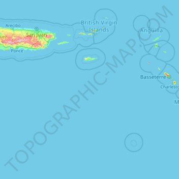
Name: Leeward Islands topographic map, elevation, terrain.
Location: Leeward Islands, United States Virgin Islands, United States (15.20763 -65.57778 18.74958 -61.00130)
Average elevation: 9 m
Minimum elevation: -1 m
Maximum elevation: 1,158 m
Thank you for supporting this site ❤️
Make a donation
Make a donation
Other topographic maps
Click on a map to view its topography, its elevation and its terrain.
Little Saint James Island
United States > United States Virgin Islands > Saint Thomas - Saint John District
Average elevation: 1 m