
Strathpeffer topographic map
Click on the map to display elevation.
Strathpeffer
It lies in a strath 5 miles (8 km) west of Dingwall, with the elevation ranging from 60 to 120 m (200 to 400 ft) above sea level. Sheltered on the west and north, it has a comparatively dry and warm climate.
About this map
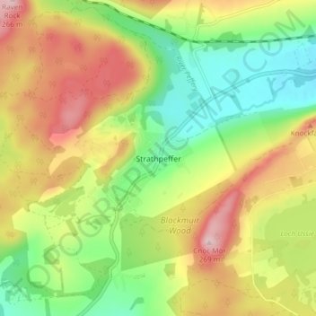
Name: Strathpeffer topographic map, elevation, terrain.
Location: Strathpeffer, Highland, Scotland, IV14 9DW, United Kingdom (57.56801 -4.55819 57.60801 -4.51819)
Average elevation: 127 m
Minimum elevation: 18 m
Maximum elevation: 262 m
Other topographic maps
Click on a map to view its topography, its elevation and its terrain.