
Haut-Rhin topographic map
Interactive map
Click on the map to display elevation.
About this map
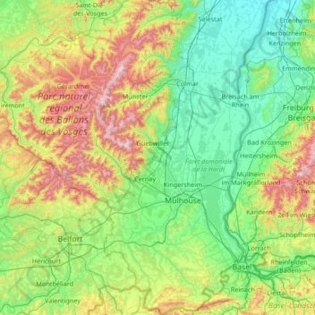
Name: Haut-Rhin topographic map, elevation, terrain.
Location: Haut-Rhin, Grand Est, Metropolitan France, France (47.42034 6.84132 48.31134 7.62201)
Average elevation: 444 m
Minimum elevation: 155 m
Maximum elevation: 1,392 m
Other topographic maps
Click on a map to view its topography, its elevation and its terrain.
Berg-sur-Moselle
Berg-sur-Moselle, Thionville, Moselle, Grand Est, Metropolitan France, 57570, France
Average elevation: 168 m
Hagenthal-le-Bas
France > Grand Est > Haut-Rhin
Hagenthal-le-Bas, Mulhouse, Haut-Rhin, Grand Est, Metropolitan France, 68220, France
Average elevation: 395 m
Le Baneau
France > Grand Est > Ardennes > Vaux-lès-Mouzon
Le Baneau, Vaux-lès-Mouzon, Sedan, Ardennes, Grand Est, Metropolitan France, 08210, France
Average elevation: 214 m
Huttendorf
France > Grand Est > Bas-Rhin > Huttendorf
Huttendorf, Haguenau-Wissembourg, Bas-Rhin, Grand Est, Metropolitan France, 67270, France
Average elevation: 221 m
Katzenthal
France > Grand Est > Katzenthal
Katzenthal, Colmar-Ribeauvillé, Haut-Rhin, Grand Est, Metropolitan France, 68230, France
Average elevation: 293 m
Saint-Gilles
France > Grand Est > Saint-Gilles
Saint-Gilles, Reims, Marne, Grand Est, Metropolitan France, 51170, France
Average elevation: 118 m
Village-Neuf
France > Grand Est > Village-Neuf
Village-Neuf, Mulhouse, Haut-Rhin, Grand Est, Metropolitan France, 68128, France
Average elevation: 248 m
Les Plattes
France > Grand Est > Tilly-sur-Meuse
Les Plattes, Tilly-sur-Meuse, Verdun, Meuse, Grand Est, Metropolitan France, 55220, France
Average elevation: 252 m
Thionville
France > Grand Est > Thionville
Thionville, Moselle, Grand Est, Metropolitan France, 57100, France
Average elevation: 190 m
Niedermorschwihr
France > Grand Est > Niedermorschwihr
Niedermorschwihr, Colmar-Ribeauvillé, Haut-Rhin, Grand Est, Metropolitan France, 68230, France
Average elevation: 339 m
Strasbourg
Strasbourg, Bas-Rhin, Grand Est, Metropolitan France, France
Average elevation: 144 m
Oberhaslach
France > Grand Est > Oberhaslach
Oberhaslach, Molsheim, Bas-Rhin, Grand Est, Metropolitan France, 67280, France
Average elevation: 439 m
Dombasle-sur-Meurthe
France > Grand Est > Dombasle-sur-Meurthe
Dombasle-sur-Meurthe, Nancy, Meurthe-et-Moselle, Grand Est, Metropolitan France, 54110, France
Average elevation: 235 m
Mouterhouse
France > Grand Est > Mouterhouse
Mouterhouse, Sarreguemines, Moselle, Grand Est, Metropolitan France, 57620, France
Average elevation: 313 m
Châteauvillain
France > Grand Est > Châteauvillain
Châteauvillain, Chaumont, Haute-Marne, Grand Est, Metropolitan France, 52120, France
Average elevation: 286 m
Rue du Moulin
Rue du Moulin, Estissac, Troyes, Aube, Grand Est, Metropolitan France, 10190, France
Average elevation: 149 m
Vitry-le-François
France > Grand Est > Vitry-le-François
Vitry-le-François, Marne, Grand Est, Metropolitan France, 51300, France
Average elevation: 101 m
La Chapelle
France > Grand Est > La Chapelle
La Chapelle, Châlons-en-Champagne, Marne, Grand Est, Metropolitan France, France
Average elevation: 171 m
Logny-Bogny
France > Grand Est > Logny-Bogny
Logny-Bogny, Charleville-Mézières, Ardennes, Grand Est, Metropolitan France, 08150, France
Average elevation: 236 m
Philippsbourg
France > Grand Est > Philippsbourg
Philippsbourg, Sarreguemines, Moselle, Grand Est, Metropolitan France, 57230, France
Average elevation: 293 m
Charleville-Mézières
France > Grand Est > Charleville-Mézières
Charleville-Mézières, Ardennes, Grand Est, Metropolitan France, 08000, France
Average elevation: 201 m