
Thank you for supporting this site ❤️
Make a donation
Make a donation
Liège topographic map
Click on the map to display elevation.
Thank you for supporting this site ❤️
Make a donation
Make a donation
About this map
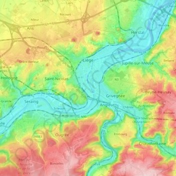
Name: Liège topographic map, elevation, terrain.
Location: Liège, Wallonia, 4000, Belgium (50.56102 5.52339 50.68820 5.67526)
Average elevation: 148 m
Minimum elevation: 54 m
Maximum elevation: 286 m
Thank you for supporting this site ❤️
Make a donation
Make a donation
Other topographic maps
Click on a map to view its topography, its elevation and its terrain.