
Thank you for supporting this site ❤️
Make a donation
Make a donation
Capel Curig topographic map
Click on the map to display elevation.
Thank you for supporting this site ❤️
Make a donation
Make a donation
About this map
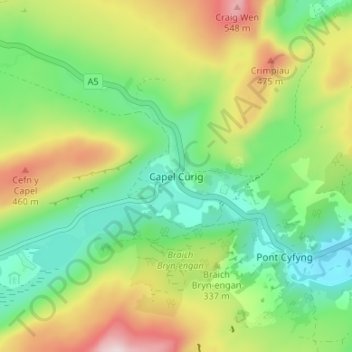
Name: Capel Curig topographic map, elevation, terrain.
Location: Capel Curig, Conwy, Wales, LL24 0EN, United Kingdom (53.08505 -3.93235 53.12505 -3.89235)
Average elevation: 299 m
Minimum elevation: 140 m
Maximum elevation: 566 m
Thank you for supporting this site ❤️
Make a donation
Make a donation
Other topographic maps
Click on a map to view its topography, its elevation and its terrain.