
Thank you for supporting this site ❤️
Make a donation
Make a donation
Kenilworth topographic map
Click on the map to display elevation.
Thank you for supporting this site ❤️
Make a donation
Make a donation
About this map
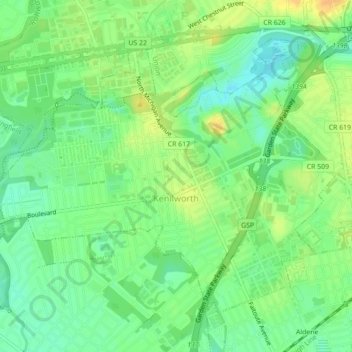
Name: Kenilworth topographic map, elevation, terrain.
Location: Kenilworth, Union County, New Jersey, 07033, United States (40.66519 -74.31317 40.69110 -74.26935)
Average elevation: 28 m
Minimum elevation: 14 m
Maximum elevation: 43 m
Thank you for supporting this site ❤️
Make a donation
Make a donation
Other topographic maps
Click on a map to view its topography, its elevation and its terrain.
Thank you for supporting this site ❤️
Make a donation
Make a donation
Thank you for supporting this site ❤️
Make a donation
Make a donation
Staten Island Junction
United States > New Jersey > Union County > Cranford > Staten Island Junction
Average elevation: 24 m