
Make a donation
Magsaysay topographic map
Click on the map to display elevation.
Make a donation
About this map
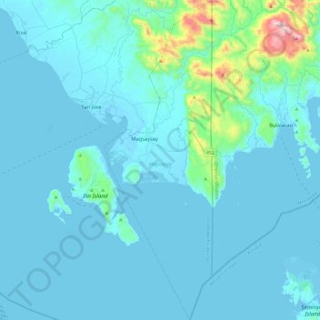
Name: Magsaysay topographic map, elevation, terrain.
Location: Magsaysay, Occidental Mindoro, Mimaropa, Philippines (12.09719 121.08630 12.50453 121.24394)
Average elevation: 70 m
Minimum elevation: -2 m
Maximum elevation: 884 m
Make a donation
Other topographic maps
Click on a map to view its topography, its elevation and its terrain.
Make a donation
Make a donation
Wawa Lighthouse
Philippines > Occidental Mindoro > Abra de Ilog > Lumang Bayan
Average elevation: 26 m
Make a donation
Make a donation
Make a donation
Cabra Island
Philippines > Occidental Mindoro > Lubang
With a length of about 4.5 km (2.8 miles) and about 2.9 km (1.8 miles) at its widest, the island has a flat terrain with the highest elevation at 60.96 metres (around 200 feet). A particular rock islet near one beach is considered by locals as a symbol of the island given its shape as a cabra (Spanish for…
Average elevation: 17 m
Make a donation
Make a donation
Make a donation
Make a donation
Make a donation
Make a donation