Geolocate
👉 Easily get elevation data in JSON, GeoTIFF and KML formats using Elevation API
Thank you for supporting this site ❤️
Make a donation

Talikud topographic map

Click on the map to display elevation.

👉 Easily get elevation data in JSON, GeoTIFF and KML formats using Elevation API
Thank you for supporting this site ❤️
Make a donation

About this map

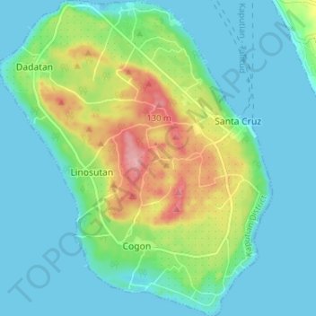
Name: Talikud topographic map, elevation, terrain.

Location: Talikud, Samal, Davao del Norte, Davao Region, Philippines (6.89794 125.66872 6.96196 125.72466)

Average elevation: 35 m

Minimum elevation: -2 m

Maximum elevation: 139 m

Other topographic maps

Click on a map to view its topography, its elevation and its terrain.

Aumbay

Philippines > Davao del Norte > Samal

Average elevation: 162 m

Buhangin

Philippines > Davao del Norte > Samal

Average elevation: 193 m