
Aubagne topographic map
Interactive map
Click on the map to display elevation.
About this map
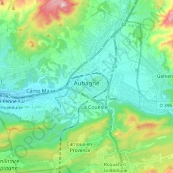
Name: Aubagne topographic map, elevation, terrain.
Average elevation: 219 m
Minimum elevation: 74 m
Maximum elevation: 702 m
Other topographic maps
Click on a map to view its topography, its elevation and its terrain.
Martigues
France > Provence-Alpes-Côte d'Azur > Bouches-du-Rhône
Martigues, Istres, Bouches-du-Rhône, Provence-Alpes-Côte d'Azur, Metropolitan France, France
Average elevation: 35 m