
Grasse topographic map
Interactive map
Click on the map to display elevation.
About this map
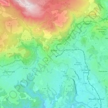
Name: Grasse topographic map, elevation, terrain.
Average elevation: 402 m
Minimum elevation: 39 m
Maximum elevation: 1,243 m
Other topographic maps
Click on a map to view its topography, its elevation and its terrain.
Nice
France > Provence-Alpes-Côte d'Azur > Maritime Alps
Nice, Maritime Alps, Provence-Alpes-Côte d'Azur, Metropolitan France, France
Average elevation: 107 m