
Thank you for supporting this site ❤️
Make a donation
Make a donation
Gdańsk topographic map
Click on the map to display elevation.
Thank you for supporting this site ❤️
Make a donation
Make a donation
About this map
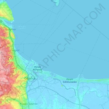
Name: Gdańsk topographic map, elevation, terrain.
Location: Gdańsk, Pomeranian Voivodeship, Poland (54.27492 18.42950 54.58273 19.07030)
Average elevation: 13 m
Minimum elevation: -5 m
Maximum elevation: 168 m
Thank you for supporting this site ❤️
Make a donation
Make a donation
Other topographic maps
Click on a map to view its topography, its elevation and its terrain.
Thank you for supporting this site ❤️
Make a donation
Make a donation
Thank you for supporting this site ❤️
Make a donation
Make a donation
Thank you for supporting this site ❤️
Make a donation
Make a donation
Zbiornik Czymanowo
Poland > Pomeranian Voivodeship > Wejherowo County > Strzebielinek
Average elevation: 94 m
Thank you for supporting this site ❤️
Make a donation
Make a donation
Thank you for supporting this site ❤️
Make a donation
Make a donation
Jezioro Ryńskie
Poland > Pomeranian Voivodeship > Bytów County > Kłączno > Rynszt
Average elevation: 162 m
Thank you for supporting this site ❤️
Make a donation
Make a donation
Jezioro Krętek
Poland > Pomeranian Voivodeship > Człuchów County > Płaszczyca
Average elevation: 154 m
Thank you for supporting this site ❤️
Make a donation
Make a donation
Thank you for supporting this site ❤️
Make a donation
Make a donation
Gozdawa-Osada
Poland > Pomeranian Voivodeship > Nowy Dwór Gdański County > Gozdawa-Osada
Average elevation: -1 m
Thank you for supporting this site ❤️
Make a donation
Make a donation
Thank you for supporting this site ❤️
Make a donation
Make a donation