
Thank you for supporting this site ❤️
Make a donation
Make a donation
Jayawijaya topographic map
Click on the map to display elevation.
Thank you for supporting this site ❤️
Make a donation
Make a donation
About this map
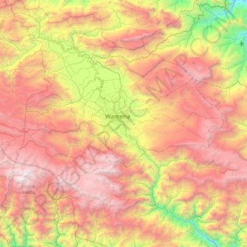
Name: Jayawijaya topographic map, elevation, terrain.
Location: Jayawijaya, Highland Papua, Western New Guinea, Indonesia (-4.47843 138.58310 -3.75421 139.25725)
Average elevation: 2,469 m
Minimum elevation: 489 m
Maximum elevation: 4,531 m
Thank you for supporting this site ❤️
Make a donation
Make a donation
Other topographic maps
Click on a map to view its topography, its elevation and its terrain.
Thank you for supporting this site ❤️
Make a donation
Make a donation
Wamena
Indonesia > Highland Papua > Jayawijaya
Wamena features a tropical rainforest climate (Köppen Af), albeit a relatively mild version due to its high altitude.
Average elevation: 2,287 m
Thank you for supporting this site ❤️
Make a donation
Make a donation
Thank you for supporting this site ❤️
Make a donation
Make a donation
Thank you for supporting this site ❤️
Make a donation
Make a donation