
Thank you for supporting this site ❤️
Make a donation
Make a donation
Mount Kinabalu topographic map
Click on the map to display elevation.
Thank you for supporting this site ❤️
Make a donation
Make a donation
Mount Kinabalu
Mount Kinabalu (Dusun: Gayo Ngaran or Nulu Nabalu, Malay: Gunung Kinabalu) is the highest mountain in Borneo and Malaysia. With an elevation of 4,095 metres (13,435 ft), it is the third-highest peak of an island on Earth, the 28th highest peak in Southeast Asia, and 20th most prominent mountain in the world. The mountain is located in Ranau district, West Coast Division of Sabah, Malaysia. It is protected as Kinabalu Park, a World Heritage Site.
Thank you for supporting this site ❤️
Make a donation
Make a donation
About this map
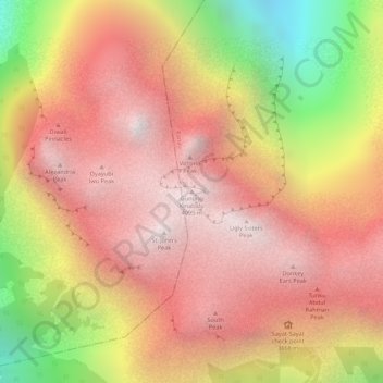
Name: Mount Kinabalu topographic map, elevation, terrain.
Location: Mount Kinabalu, Ranau, West Coast Division, Sabah, Malaysia (6.07502 116.55865 6.07512 116.55875)
Average elevation: 3,567 m
Minimum elevation: 2,661 m
Maximum elevation: 4,062 m
Thank you for supporting this site ❤️
Make a donation
Make a donation