
Thank you for supporting this site ❤️
Make a donation
Make a donation
Tralee topographic map
Click on the map to display elevation.
Thank you for supporting this site ❤️
Make a donation
Make a donation
About this map
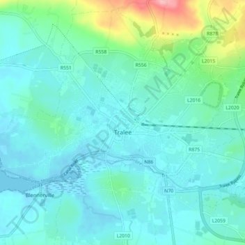
Name: Tralee topographic map, elevation, terrain.
Location: Tralee, County Kerry, Munster, Ireland (52.24844 -9.75065 52.29416 -9.66232)
Average elevation: 23 m
Minimum elevation: -2 m
Maximum elevation: 128 m
Thank you for supporting this site ❤️
Make a donation
Make a donation
Other topographic maps
Click on a map to view its topography, its elevation and its terrain.