Geolocate

Aklan topographic map

Click on the map to display elevation.

Aklan

Mount Nausang, is formerly the highest peak in Aklan, standing at 5,190 ft (1,580 m), the discovery of Mount Timbaban is much higher, with an elevation of 5,830.1 ft (1,777.0 m) above sea level, Mount Timbaban is not considered as independent mountain, it is still part of Mount Madja-as sub-summit with only Topographic prominence peak of 30 m (98 ft) above the isolation from the Parent peak. Located 6 km northwest of Mount Nausang and 4.8 km northeast of Mount Madja-as in Antique. Aklan River, is the longest river in the province with a total length of 91 km (57 mi) long.

Wikipedia (CC-BY-SA 3.0)

About this map

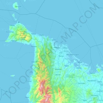
Name: Aklan topographic map, elevation, terrain.

Location: Aklan, Western Visayas, Philippines (11.31761 121.73877 12.03555 122.59750)

Average elevation: 96 m

Minimum elevation: -2 m

Maximum elevation: 2,023 m

Other topographic maps

Click on a map to view its topography, its elevation and its terrain.

Quezon City

Philippines

Founded as a pueblo by Saint Pedro Bautista in 1590, San Francisco del Monte may be considered Quezon City's oldest district. The original land area of the old town of San Francisco del Monte was approximately2.5 square kilometres (1.0 sq mi) and covered parts of what is currently known as Project 7 and 8 and…

Average elevation: 57 m

Cebu City

Philippines > Cebu > Cebu City

Average elevation: 140 m

Bacolod

Philippines

Bacólod (English: Bacolod), is derived from bakólod (Old Spelling: bacólod), the Old Hiligaynon (Old Ilonggo) (Old Spelling: Ylongo and Ilongo) word for a "hill, turtle, mound, rise, hillock, down, any small eminence or elevation", since the resettlement was founded on a stony, hilly area, now the barangay…

Average elevation: 49 m

Mandaue

Philippines

It is one of the two (the other one being the municipality of Consolacion) local government units located within the mainland Metro Cebu where the elevation of land is less than 100 m (330 ft).

Average elevation: 109 m

Baguio

Philippines

In 1903, Filipinos, Japanese and Chinese workers were hired to build Kennon Road, the first road directly connecting Baguio with the lowlands of La Union and Pangasinan. Before this, the only road to Benguet was Naguilian Road, and it was largely a horse trail at higher elevations. Camp John Hay was…

Average elevation: 881 m

San Juan

Philippines

"San Juan" is a contraction of the city's traditional name of "San Juan del Monte" (lit. 'Saint John of the Mountain'). As with numerous other places in the Philippines, the name combines a patron saint and a toponym; in this case Saint John the Baptist with the locale's hilly terrain and relatively higher…

Average elevation: 35 m

Lagundi

Philippines > Pampanga

Average elevation: 6 m

Calapan

Philippines > Oriental Mindoro

The overall land characteristic is a wide plain with rivers, interspersed with wetlands at the seacoast periphery. The highest elevation is 187 m (614 ft) above sea level at Bulusan Hill, a 6-kilometre (3.7 mi) long landform east of the city, which interrupts the mostly flat terrain north-east of the…

Average elevation: 40 m

Tagaytay

Philippines > Cavite

The southern and eastern portions of Tagaytay are covered by hills and mountains which is generally forests, pine trees and open grasslands. The city lies along Tagaytay Ridge, a ridge stretching about 32 kilometres (20 mi) from Mount Batulao in the west to Mount Sungay in the east with elevations averaging…

Average elevation: 229 m

Antipolo

Philippines > Rizal

Its higher elevation than that of Metro Manila affords it a scenic view of the metropolis, especially at night. Its locally grown mangoes and cashews are popular among tourists, as well as suman – a local delicacy made out of glutinous rice. The Hinulugang Taktak National Park, which was once a popular…

Average elevation: 125 m

Legazpi

Philippines > Albay

Legazpi's topography is generally plain on the northeastern areas, with slopes ranging from five to fifteen degrees. The southern areas have mostly rolling to hilly terrain. In the city's coastal areas, the terrain varies from plain (north) to hilly (south). Legazpi is criss-crossed by several rivers including…

Average elevation: 150 m

Tacloban

Philippines > Leyte > Tacloban

Average elevation: 29 m

Medellin

Philippines > Cebu

Average elevation: 11 m

Trece Martires

Philippines > Cavite

The city of Trece Martires is characterised with ground elevation ranging from 30m to nearly 400m. Its ground slope ranges from 0.5 to 2%.

Average elevation: 150 m

Iligan

Philippines

Average elevation: 229 m

Cabanatuan

Philippines > Nueva Ecija

Average elevation: 47 m

Lapu-Lapu

Philippines

Average elevation: 93 m

Butuan

Philippines

Average elevation: 115 m

Pinaltakan

Philippines > Nueva Ecija > Palayan

Average elevation: 114 m

Tabuelan

Philippines > Cebu

Average elevation: 45 m

Lake Sebu

Philippines > South Cotabato

The placid lake of Lake Sebu can be found in Allah Valley near the municipality of Surallah, South Cotabato. Surrounded by rolling hills and mountains covered with thick rain forest, the lake has an area of 361.124 hectares (892.36 acres), with an elevation of approximately 1,000 metres (3,300 ft).

Average elevation: 750 m

Bacoor

Philippines > Cavite

Average elevation: 18 m

Valencia

Philippines > Bukidnon

The city's topography is characterized as flat to undulating hills with extensive plateaus and mountainous areas and cliffs on both eastern and western portions bounding the municipality of San Fernando on the east and the municipality of Talakag on the west. Its highest point is Mount Kalatungan in the…

Average elevation: 566 m

Palo

Philippines > Leyte > Palo

Average elevation: 11 m

Dagupan

Philippines > Pangasinan

Average elevation: 12 m

Sorsogon City

Philippines > Sorsogon

Sorsogon City covers a land area of 31,292 hectares (120.82 sq mi). It is at the southernmost tip of the Bicol Peninsula and of Luzon Island. The city is bounded by Castilla in the west, Manito in the northwest, Albay Gulf in the north, Prieto Diaz in the east, Gubat in the southeast, Casiguran in the…

Average elevation: 89 m

Vigan

Philippines > Ilocos Sur

Vigan is situated in a Quaternary Age sedimentary plain called the Vigan-Bantay Plain which is part of the Ilocos coastal plain. The Vigan-Bantay Plain is bounded on the east by a moderately rugged Miocene sediments consisting of interbedded sandstones and shale to very rugged Meta-volcanics and Meta sediment…

Average elevation: 63 m

Mandaluyong

Philippines

Another claims that the Spaniards named the place based on the report of a navigator named Acapulco, who saw the rolling hills frequently being lashed at by daluyong (“big waves from the sea”). This seems to confirm traditional pre-Hispanic stories that giant waves from the sea would meet the adjoining…

Average elevation: 33 m

Calamba

Philippines > Laguna

Average elevation: 100 m

Patag Island

Philippines

Average elevation: 0 m

Kota Island

Philippines

Average elevation: 0 m

Barili

Philippines > Cebu

Average elevation: 81 m

Iriga

Philippines > Camarines Sur

Average elevation: 115 m

Guiguinto

Philippines > Bulacan

Average elevation: 5 m

Talim Island

Philippines > Rizal > Kinaboogan

Average elevation: 13 m

San Fernando

Philippines > La Union

Average elevation: 81 m

Meycauayan

Philippines > Bulacan

Average elevation: 27 m

Daraga

Philippines > Albay

67.3% of the total municipal land area has a predominantly low elevation of up to 100 metres (330 ft). The surface terrain is generally characterized by combination of level to nearly level areas, gentle to undulating areas and undulating to rolling areas.

Average elevation: 76 m

Pasay

Philippines

Average elevation: 14 m

Malolos

Philippines > Bulacan

Malolos is relatively flat of about 0.81% to a gently sloping of 2.17%. The slope of the land descends towards west, southwest to southern direction. The highest land elevation is at about 6.0 meters above sea level while the lowest is only half a meter below sea level. A network of natural waterways and…

Average elevation: 6 m

Baguingey

Philippines > Benguet > Itogon

Average elevation: 914 m

Tabina

Philippines > Zamboanga del Sur

Average elevation: 53 m

Lankiam Cay

Philippines

Average elevation: 0 m

Balangiga

Philippines > Eastern Samar

Average elevation: 27 m

Davao Gulf

Philippines

Average elevation: 0 m

Libmanan

Philippines > Camarines Sur

Average elevation: 6 m

Bantay

Philippines > Ilocos Sur

It has an average elevation of 100 meters (328.08 feet), with a land area of 7,660 hectares (18,900 acres). It is an elevated and hilly municipality but some barangays, especially those near creeks, are prone to flooding during heavy typhoons.

Average elevation: 8 m

Limba-an

Philippines > Davao del Norte > New Corella

Average elevation: 39 m

Mount Tabayoc

Philippines > Ifugao

Average elevation: 2,406 m

Mount Piapayungan

Philippines > Lanao del Sur

Mount Ragang, also called Mount Piapayungan and Blue Mountain by the local people, is an active stratovolcano on Mindanao island in the Philippines. With an elevation of 2,815 metres (9,236 ft), it is the seventh highest mountain in the Philippines and the highest point in the Lanao del Sur province.

Average elevation: 2,394 m

Alfonso

Philippines > Cavite > Alfonso

Average elevation: 413 m

Tanay

Philippines > Rizal

Average elevation: 32 m

Urdaneta

Philippines > Pangasinan

Average elevation: 42 m

San Pablo

Philippines > Laguna > San Pablo

Average elevation: 220 m

Agno

Philippines > Pangasinan

Average elevation: 42 m

Alcantara

Philippines > Cebu

Average elevation: 41 m

Lullutan

Philippines > Isabela

Average elevation: 39 m

Badoc Island

Philippines > Ilocos Norte

Average elevation: 1 m

Cagmanaba

Philippines > Camarines Sur

Average elevation: 41 m

Maigo

Philippines > Lanao del Norte

Average elevation: 36 m

Tabaan Sur

Philippines > Benguet

Average elevation: 676 m

Mother Falls

Philippines > Aurora

Average elevation: 452 m

Sabang

Philippines > Samar > Calbayog > Cagsalaosao

Average elevation: 11 m

Igbaras

Philippines > Iloilo

Average elevation: 103 m

Burdeos

Philippines > Quezon

Average elevation: 44 m

Mount Pinatubo

Philippines > Zambales

Even before the 1991 eruption, Mount Pinatubo had little topographic prominence: it was 1,745 m (5,725 ft) above sea level, only about 600 m (2,000 ft) above nearby plains, and only about 200 m (660 ft) higher than surrounding peaks, which largely obscured it from view. It is part of a chain of volcanoes which…

Average elevation: 1,047 m

Bindoy

Philippines > Negros Oriental

Average elevation: 128 m

Bakun

Philippines > Benguet

Average elevation: 1,458 m

Pias

Philippines > Ilocos Sur

Average elevation: 60 m

Liloan

Philippines > Cebu

Average elevation: 17 m

San Andres

Philippines > Quezon

Average elevation: 83 m

San Antonio

Philippines > Zambales

Average elevation: 57 m

Lubing

Philippines > Ilocos Sur

Average elevation: 238 m

Matnog

Philippines > Sorsogon

Average elevation: 46 m

Santa Barbara

Philippines > Iloilo

The topography of Santa Barbara varies from slightly rolling hills to almost flat or gradually inclined plains, sliced by Tigum River at its centremost, which flows from the north-west to the southeast and the Aganan River in the southern section.

Average elevation: 34 m

Argao

Philippines > Cebu

Average elevation: 31 m

Buenavista

Philippines > Quezon

Average elevation: 66 m

Dipolog

Philippines > Zamboanga del Norte

Average elevation: 40 m

Mount Halcon

Philippines > Oriental Mindoro

Mount Halcon (Filipino: Bundok Halcon) and (Spanish: Monte Halcón) is the highest mountain in Mindoro. According to the new data released by Oriental Mindoro peakvisor as of 2022, it has an elevation of 2,616 metres (8,583 ft) above sea level, higher than the previous estimates of 2,586 m (8,484 ft) although…

Average elevation: 2,121 m

Laguindingan

Philippines > Misamis Oriental

Average elevation: 71 m

Mount Kitanglad

Philippines > Bukidnon > Impasugong

Due to its high elevation, several communications and broadcasting companies constructed relay stations at the summit.

Average elevation: 2,393 m

Nasipit

Philippines > Agusan del Norte

Average elevation: 24 m

Mabuhay

Philippines > Surigao del Sur

Average elevation: 65 m

Paulog

Philippines > Albay

Average elevation: 92 m

Tullahan River

Philippines > Quezon City

Average elevation: 39 m

Tocmo

Philippines > Benguet

Average elevation: 1,264 m

San Isidro

Philippines > Sorsogon

Average elevation: 23 m

Rizal

Philippines

Average elevation: 95 m

Buguias

Philippines > Benguet

Average elevation: 1,674 m

Tabaco

Philippines > Albay

The City of Tabaco is located on the eastern coast of Albay province with an area of 117.14 km2 (45.23 sq mi). The terrain in the poblacion or town center of Tabaco is generally flat with the highest elevation at around 5 m (16 ft). The northwestern portion reaches 400 m (1,300 ft) above sea level. The city's…

Average elevation: 182 m

Tayabas

Philippines > Quezon

Average elevation: 246 m

Bacnotan

Philippines > La Union

The topography of the town is characterized by hilly and mountainous terrain rising gradually eastward. The western side of Bacnotan is defined by a long stretch of black sand beaches facing the South China Sea, indicative of the area's abundant magnetite deposits. Certain parts of the coastline also feature…

Average elevation: 21 m

Santa Rosa

Philippines > Laguna > Santa Rosa

Average elevation: 65 m

Ilagan

Philippines > Isabela

Abuan River is the main river of the Northern Sierra Madre Natural Park. It has an average elevation of 82 meters above sea level, and feeds the Abuan watershed in the city. Tourists and visitors can explore the diverse animal and plant life in one of the country’s remaining lush virgin forests. On January…

Average elevation: 123 m

Zamboanga City

Philippines > Zamboanga Peninsula > Zamboanga City

The overall topography of the city could be described as rolling to very steep. There are some flat lands, mostly narrow strips along the east coast. The urban center is mostly flat with a gentle slope to the interior, ranging from 0 to 3%. The highest registered elevation is 1,200 metres. In terms of slope, a…

Average elevation: 83 m

San Fernando

Philippines > Pampanga

Average elevation: 24 m