
Shaoxing topographic map
Interactive map
Click on the map to display elevation.
About this map
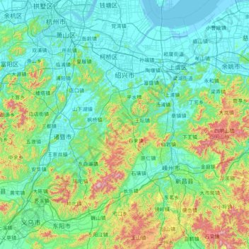
Name: Shaoxing topographic map, elevation, terrain.
Location: Shaoxing, Zhejiang, China (29.22651 119.88419 30.29944 121.22714)
Average elevation: 180 m
Minimum elevation: -3 m
Maximum elevation: 1,173 m
Other topographic maps
Click on a map to view its topography, its elevation and its terrain.
三都镇
China > Zhejiang > Hangzhou City > 三都镇
三都镇, Hangzhou City, Jiande, Zhejiang, China
Average elevation: 186 m