
Frosinone topographic map
Interactive map
Click on the map to display elevation.
About this map
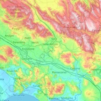
Name: Frosinone topographic map, elevation, terrain.
Location: Frosinone, Lazio, Italy (41.30135 12.99187 41.95545 14.02764)
Average elevation: 668 m
Minimum elevation: -3 m
Maximum elevation: 2,232 m
Other topographic maps
Click on a map to view its topography, its elevation and its terrain.
Monte Testaccio
Monte Testaccio, Via della Pelanda, Rione XX Testaccio, Municipio Roma I, Rome, Roma Capitale, Lazio, 00153, Italy
Average elevation: 35 m
Municipio Roma VII
Municipio Roma VII, Rome, RM, Lazio, Italy
Average elevation: 83 m
Acquapendente
Italy > Lazio > Acquapendente
Acquapendente, VT, Lazio, 01021, Italy
Average elevation: 430 m