
Thank you for supporting this site ❤️
Make a donation
Make a donation
Sechelt topographic map
Click on the map to display elevation.
Thank you for supporting this site ❤️
Make a donation
Make a donation
About this map
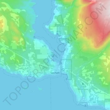
Name: Sechelt topographic map, elevation, terrain.
Average elevation: 196 m
Minimum elevation: -1 m
Maximum elevation: 1,145 m
Thank you for supporting this site ❤️
Make a donation
Make a donation
Other topographic maps
Click on a map to view its topography, its elevation and its terrain.
Mount Albert
Canada > British Columbia > Sunshine Coast Regional District > Area A (Egmont/Pender Harbour)
Average elevation: 1,937 m
Garden Bay
Canada > British Columbia > Sunshine Coast Regional District > Area A (Egmont/Pender Harbour)
Average elevation: 79 m