
Thank you for supporting this site ❤️
Make a donation
Make a donation
Fort Worth topographic map
Click on the map to display elevation.
Thank you for supporting this site ❤️
Make a donation
Make a donation
About this map
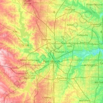
Name: Fort Worth topographic map, elevation, terrain.
Location: Fort Worth, Tarrant County, Texas, United States (32.55158 -97.59239 33.04953 -97.03358)
Average elevation: 212 m
Minimum elevation: 133 m
Maximum elevation: 333 m
Thank you for supporting this site ❤️
Make a donation
Make a donation
Other topographic maps
Click on a map to view its topography, its elevation and its terrain.
Thank you for supporting this site ❤️
Make a donation
Make a donation
Thank you for supporting this site ❤️
Make a donation
Make a donation
Thank you for supporting this site ❤️
Make a donation
Make a donation
Will Rogers Memorial Center
United States > Texas > Tarrant County > Fort Worth
Average elevation: 181 m
Thank you for supporting this site ❤️
Make a donation
Make a donation
Thank you for supporting this site ❤️
Make a donation
Make a donation