
Thank you for supporting this site ❤️
Make a donation
Make a donation
Jempol topographic map
Click on the map to display elevation.
Thank you for supporting this site ❤️
Make a donation
Make a donation
About this map
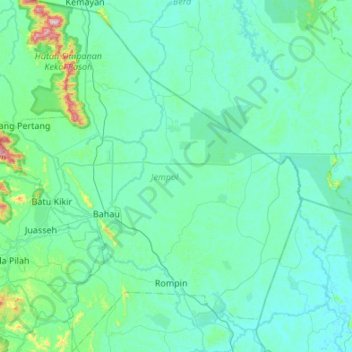
Name: Jempol topographic map, elevation, terrain.
Location: Jempol, Negeri Sembilan, Malaysia (2.59857 102.23744 3.13722 102.70106)
Average elevation: 79 m
Minimum elevation: 8 m
Maximum elevation: 765 m
Thank you for supporting this site ❤️
Make a donation
Make a donation
Other topographic maps
Click on a map to view its topography, its elevation and its terrain.