
Thank you for supporting this site ❤️
Make a donation
Make a donation
Llandrillo topographic map
Click on the map to display elevation.
Thank you for supporting this site ❤️
Make a donation
Make a donation
About this map
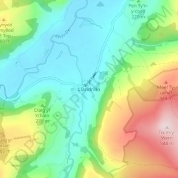
Name: Llandrillo topographic map, elevation, terrain.
Location: Llandrillo, Denbighshire, Wales, LL21 0SQ, United Kingdom (52.90217 -3.45449 52.94217 -3.41449)
Average elevation: 272 m
Minimum elevation: 141 m
Maximum elevation: 550 m
Thank you for supporting this site ❤️
Make a donation
Make a donation