
Inverurie topographic map
Click on the map to display elevation.
About this map
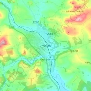
Name: Inverurie topographic map, elevation, terrain.
Location: Inverurie, Aberdeenshire, Scotland, AB51 3SN, United Kingdom (57.24395 -2.41429 57.32395 -2.33429)
Average elevation: 102 m
Minimum elevation: 45 m
Maximum elevation: 242 m
Other topographic maps
Click on a map to view its topography, its elevation and its terrain.