
Thank you for supporting this site ❤️
Make a donation
Make a donation
Llandudno topographic map
Click on the map to display elevation.
Thank you for supporting this site ❤️
Make a donation
Make a donation
About this map
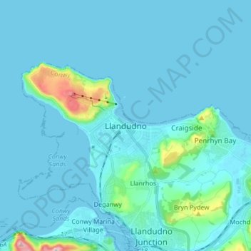
Name: Llandudno topographic map, elevation, terrain.
Location: Llandudno, Conwy, Wales, LL30 1AH, United Kingdom (53.28248 -3.86433 53.36248 -3.78433)
Average elevation: 19 m
Minimum elevation: 0 m
Maximum elevation: 240 m
Thank you for supporting this site ❤️
Make a donation
Make a donation
Other topographic maps
Click on a map to view its topography, its elevation and its terrain.
Thank you for supporting this site ❤️
Make a donation
Make a donation
Thank you for supporting this site ❤️
Make a donation
Make a donation
Thank you for supporting this site ❤️
Make a donation
Make a donation
Thank you for supporting this site ❤️
Make a donation
Make a donation
Thank you for supporting this site ❤️
Make a donation
Make a donation