
Make a donation
Gijón topographic map
Click on the map to display elevation.
Make a donation
Gijón
The city is situated on the coast of central Asturias, from sea level to an altitude of 513 m (1,683 ft) at Picu Samartín and 672 m (2,205 ft) at Peña de los Cuatro Jueces, bordered on the West by Carreño, the East by Villaviciosa, and to the South by Siero and Llanera. The city is situated along the Asturian coast and is distinguished by the peninsula of Cimavilla (the original settlement) which separates the beach of San Lorenzo and adjacent neighborhoods to the east from the beaches of Poniente and Arbeyal, the shipyards, and the recreational port and the Port of El Musel to the west. It is close to the other main Asturian cities, Oviedo and Avilés.
Make a donation
About this map
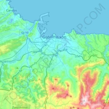
Name: Gijón topographic map, elevation, terrain.
Location: Gijón, Asturias, Spain (43.44151 -5.82132 43.58677 -5.56288)
Average elevation: 128 m
Minimum elevation: -8 m
Maximum elevation: 730 m
Make a donation
Other topographic maps
Click on a map to view its topography, its elevation and its terrain.
Make a donation
Make a donation
Cantabrian Mountains
The descent from the southern range to the high plateaus of Castile is more gradual, and several large rivers, notably the Ebro, rise here and flow to the south or west. The breadth of the Cantabrian chain, with all its ramifications, increases from about 97 km (60 mi) in the east to about 185 kilometres (115…
Average elevation: 2,209 m
Picos de Europa
The Picos de Europa ("Peaks of Europe", also the Picos) are a mountain range extending for about 20 km (12 mi), forming part of the Cantabrian Mountains in northern Spain. The range is situated in the Autonomous Communities of Asturias, Cantabria and Castile and León. The highest peak is Torre de Cerredo, at…
Average elevation: 2,290 m
Make a donation
Make a donation
Make a donation
Plaza de la Playa de Castiel
Spain > Asturias > Valdés > Luarca / Ḷḷuarca > Barceḷḷina
Average elevation: 41 m
Make a donation
Make a donation
Make a donation
Make a donation
Make a donation
Make a donation
Make a donation
Picos de Europa
The Picos de Europa ("Peaks of Europe", also the Picos) are a mountain range extending for about 20 km (12 mi), forming part of the Cantabrian Mountains in northern Spain. The range is situated in the Autonomous Communities of Asturias, Cantabria and Castile and León. The highest peak is Torre de Cerredo, at…
Average elevation: 2,290 m
Make a donation
Make a donation
Make a donation
Make a donation
Make a donation
Make a donation
Make a donation