
Make a donation
Baja California topographic map
Click on the map to display elevation.
Make a donation
Baja California
Baja California is the 12th-largest state by area in Mexico. Its geography ranges from beaches to forests and deserts. The backbone of the state is the Sierra de Baja California, where Picacho del Diablo, the highest point of the peninsula, is located. This mountain range effectively divides the weather patterns in the state. In the northwest, the weather is semi-dry and Mediterranean. In the narrow center, the weather changes to be more humid due to altitude. It is in this area where a few valleys can be found, such as the Valle de Guadalupe, the major wine-producing area in Mexico. To the east of the mountain range, the Sonoran Desert dominates the landscape. In the south, the weather becomes drier and gives way to the Vizcaíno Desert. The state is also home to numerous islands off both of its shores. Baja California is also home to Guadalupe Island, the westernmost point of Mexico. The Coronado Islands, Todos Santos islands, and Cedros Island are also on the Pacific shore. On the Gulf of California, the largest island is Angel de la Guarda Island, separated from the peninsula by the deep and narrow Canal de Ballenas.
Make a donation
About this map
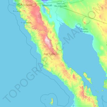
Name: Baja California topographic map, elevation, terrain.
Location: Baja California, Mexico (27.99999 -118.36506 32.71871 -112.75267)
Average elevation: 179 m
Minimum elevation: -11 m
Maximum elevation: 2,850 m
Make a donation
Other topographic maps
Click on a map to view its topography, its elevation and its terrain.
Tijuana
Mexico > Baja California > Municipio de Tijuana
Housing development in the Tijuana Hills has led to eradication of many seasonal mountain streams. This lack of natural drainage makes places within the city vulnerable to landslides during the rainy season. The varied terrain of Tijuana gives the city elevation extremes that range from sea level to 790 meters…
Average elevation: 141 m
Puerto Vallarta
Mexico > Jalisco > Puerto Vallarta
Fourth: In 1968 the Puerto Vallarta municipality was elevated to City status. The elevation in status reflected interest by Mexican federal and state governments in developing the Puerto Vallarta as an international resort destination. Puerto Vallarta has since also attracted a lively immigrant community from…
Average elevation: 306 m
Monterrey
Mexico > Nuevo León > Monterrey
The city of Monterrey is 540 metres (1,770 ft) above sea level in the northeastern state of Nuevo León. Monterrey translated literally from Spanish to English is "King Mount" or "King Mountain", and folk etymology claims that this refers to the city's topography and the large mountains that surround it…
Average elevation: 753 m
Culiacán
Culiacán is located in the central region of the State of Sinaloa, forming part of the Northwest of Mexico. The coordinates that correspond to it are 24 ° 48'15 "N (latitude) by 107 ° 25'52" W (West), with an altitude of 54 meters above sea level.
Average elevation: 85 m
Make a donation
Aguascalientes
Aguascalientes (Spanish pronunciation: [ˌaɣwaskaˈljentes] ; lit. 'Hot Springs'), officially the Free and Sovereign State of Aguascalientes (Spanish: Estado Libre y Soberano de Aguascalientes), is one of the 32 states which comprise the Federal Entities of Mexico. At 22°N and with an average altitude of…
Average elevation: 1,814 m
Zapopan
Most of the municipality is flat with another quarter having rolling hills. Altitude varies from 1,500 to 2,000 metres (4,900 to 6,600 ft) above sea level. The main elevations are in the Sierra de la Primavera and include Nejahuete, Tajo and El Chapulin. Superficial water flows mostly in arroyos east to the…
Average elevation: 1,598 m
Saltillo
El Cerro del Pueblo (The People's Hill) and its 4-metre (13 ft) cross overlook the city. The city's elevation makes it colder and windier than the neighboring city of Monterrey. Saltillo lies in the Chihuahuan Desert near the city of Arteaga. The city is flanked by the Zapalinamé mountains, which are part of…
Average elevation: 1,857 m
Make a donation
Guadalajara
Mexico > Jalisco > Guadalajara
Under the Köppen climate classification, Guadalajara has a humid subtropical climate (Cwa), a temperate climate that is quite close to a tropical climate, featuring dry warm winters and wet, mildly hot summers. Guadalajara's climate is influenced by its high altitude and the general seasonality of…
Average elevation: 1,572 m
Make a donation
Monterrey
Mexico > Nuevo León > Monterrey
The city of Monterrey is 540 metres (1,770 ft) above sea level in the northeastern state of Nuevo León. Monterrey translated literally from Spanish to English is "King Mount" or "King Mountain", and folk etymology claims that this refers to the city's topography and the large mountains that surround it…
Average elevation: 753 m
Oaxaca City
Mexico > Oaxaca > Oaxaca de Juárez
Oaxaca has a tropical savanna climate (Köppen climate classification Aw), closely bordering on a humid subtropical climate (Cwa), due to its high altitude. During the dry season, temperatures during the day remain warm with an average high of 27.1 °C (80.8 °F) in the coolest month, December, and an average…
Average elevation: 1,838 m
Saltillo
El Cerro del Pueblo (The People's Hill) and its 4-metre (13 ft) cross overlook the city. The city's elevation makes it colder and windier than the neighboring city of Monterrey. Saltillo lies in the Chihuahuan Desert near the city of Arteaga. The city is flanked by the Zapalinamé mountains, which are part of…
Average elevation: 1,857 m
Make a donation
San Luis Potosí City
Mexico > San Luis Potosi > Municipio de San Luis Potosí
San Luis Potosí, commonly called SLP or simply San Luis, is the capital and the most populous city of the Mexican state of San Luis Potosí. It is the municipal seat of the surrounding municipality of San Luis Potosí. The city lies at an elevation of 1,864 metres (6,115 feet). It has an estimated population…
Average elevation: 2,004 m
Make a donation
Cuernavaca
Mexico > Morelos > Cuernavaca
The city is located in a tropical region, but its temperature is fairly constant at 21–26 °C (70–79 °F). It is located on the southern slope of the Sierra de Chichinautzin mountains. In the morning, warm air flows up the mountains from the valley below and in the late afternoon, cooler air flows down…
Average elevation: 1,822 m
Popocatépetl
Mexico > Puebla > Tochimilco
According to paleomagnetic studies, the volcano is about 730,000 years old. It is cone shaped with a diameter of 25 km (16 mi) at its base, with a peak elevation of 5,450 m (17,880 ft). The crater is elliptical with an orientation northeast-southwest. The walls of the crater vary from 600 to 840 m (1,970 to…
Average elevation: 4,807 m
Make a donation
Zihuatanejo
Mexico > Guerrero > Zihuatanejo de Azueta
The town of Zihuatanejo is the seat of the municipality of Zihuatanejo de Azueta and as such is the governmental authority for approximately 416 communities, with a total population of 104,609 as of 2005, and an area of 1,921.5 km2 (741.9 sq mi). There are small indigenous communities in the municipality which…
Average elevation: 103 m
Ciudad Juárez
Due to its location in the Chihuahuan Desert and high altitude, Ciudad Juárez has a cold desert climate (Köppen: BWk). Seasons are distinct, with hot summers, mild springs and autumns, and cold winters. Summer average high is 35 °C (95 °F) with lows of 21 °C (70 °F). Winter highs average 14 °C (57 °F)…
Average elevation: 1,210 m
Make a donation
Morelia
Under the Köppen climate classification, Morelia has a subtropical highland climate (abbreviated Cwb on climate maps), with warm-to-hot days and cool nights year round due to its high elevation. Most precipitation falls during the summer monsoon season from June to September. Average monthly temperatures are…
Average elevation: 2,071 m
Isthmus of Tehuantepec
At its narrowest point, the isthmus is 200 km (124 mi) across from gulf to gulf, or 192 km (119 mi) to the head of Laguna Superior on the Pacific coast. The Sierra Madre del Sur mountain range breaks down at this point into a broad, plateau-like ridge, whose elevation, at the highest point reached by the…
Average elevation: 277 m
Make a donation
Rosarito
Mexico > Baja California > Municipio de Playas de Rosarito
Playas de Rosarito lies on the coast of the Pacific Ocean on the North Baja California Peninsula. The city is positioned between the foothills of the Peninsular Ranges and the ocean. It maintains a relatively uniform topography and displays few variances in terrain.
Average elevation: 103 m
Cabo San Lucas
Mexico > Baja California Sur > Los Cabos Municipality > Cabo San Lucas
Average elevation: 2 m
San Luis Potosí City
Mexico > San Luis Potosi > Municipio de San Luis Potosí
San Luis Potosí, commonly referred to as San Luis, or by its initials SLP (Otomi: Nmiñ'u), is the capital and the most populous city of the Mexican state of San Luis Potosí. It is the municipal seat of the surrounding municipality of San Luis Potosí. The city lies at an elevation of 1,864 metres (6,115…
Average elevation: 2,004 m
Make a donation
Morelia
Under the Köppen climate classification, Morelia has a subtropical highland climate (abbreviated Cwb on climate maps), with warm-to-hot days and cool nights year round due to its high elevation. Most precipitation falls during the summer monsoon season from June to September. Average monthly temperatures are…
Average elevation: 2,071 m
Xochimilco
Much of the borough's land is former lakebed. Its main elevations include Xochitepec and Tlacualleli mountains along with two volcanoes named Teutli and Tzompol. It contains two natural rivers called Santiago and Tepapantla along with the various canals, which is what is left of the lake. The elevated areas of…
Average elevation: 2,241 m
La Paz
Mexico > Baja California Sur > Municipio de La Paz
The city, in west-central Bolivia 68 km (42 mi) southeast of Lake Titicaca, is set in a canyon created by the Choqueyapu River. It is in a bowl-like depression, part of the Amazon basin, surrounded by the high mountains of the Altiplano. Overlooking the city is the towering, triple-peaked Illimani. Its peaks…
Average elevation: 114 m
Make a donation
Tijuana
Mexico > Baja California > Municipio de Tijuana
Housing development in the Tijuana Hills has led to eradication of many seasonal mountain streams. This lack of natural drainage makes places within the city vulnerable to landslides during the rainy season. The varied terrain of Tijuana gives the city elevation extremes that range from sea level to 790 meters…
Average elevation: 141 m
Make a donation
Mexico City
Mexico > Mexico City > Mexico City
Mexico City is located in the Valley of Mexico, sometimes called the Basin of Mexico. This valley is located in the Trans-Mexican Volcanic Belt in the high plateaus of south-central Mexico. It has a minimum altitude of 2,200 meters (7,200 feet) above sea level and is surrounded by mountains and volcanoes that…
Average elevation: 2,321 m
Make a donation
Toluca
Mexico > State of Mexico > Toluca
Toluca is located at 2600 meters above sea level, being the highest capital city in Mexico and North America, which makes it temperate throughout the year with average temperatures ranging between 6 and 25 degrees Celsius during spring and summer, and from −5 to 20 degrees Celsius in winter. Its climate is…
Average elevation: 2,729 m
Monterrey
Mexico > Nuevo León > Monterrey
The city of Monterrey is 540 metres (1,770 ft) above sea level in the northeastern state of Nuevo León. Monterrey translated from Spanish to English is "King Mount" or "King mountain", which refers to the city's topography and the large mountains that surround it. The Santa Catarina River—dry most of the…
Average elevation: 753 m
Colonia el Pajarito
Mexico > Oaxaca > Zimatlán de Álvarez > Zimatlán de Álvarez
Average elevation: 1,519 m
Make a donation
Chihuahua City
Mexico > Chihuahua > Municipio de Chihuahua
Chihuahua lies on the western side of the Chihuahuan Desert ecoregion and as such has a hot semi-arid climate (Köppen climate classification BSh). However, it is not as hot as most of the lower elevated portions of the desert to the east owing to an altitude of almost 1,500 metres (4,900 feet) above sea level.
Average elevation: 1,555 m
Make a donation
San Miguel de Allende
Mexico > Guanajuato > San Miguel de Allende > San Miguel de Allende
Average elevation: 2,029 m
Ciudad Obregón
The city is located on the parallel 27–29' north latitude and the meridian 109-59' west longitude. With an altitude above sea level of 40.8 m (134 ft) in the city center.
Average elevation: 59 m
Make a donation
Make a donation
Toluca
Mexico > State of Mexico > Toluca
The Lerma River flows from Lake Almoloya del Río through the center of the municipality towards the west, flowing into Lake Chapala. From this point westward the river takes the name of Río Grande de Santiago. And it goes from this lake to the Pacific Ocean in the state of Nayarit. The river is about 1,180…
Average elevation: 2,729 m
Make a donation
Make a donation
Puebla City
Mexico > Puebla > Municipio de Puebla
The Sierra del Tentzon and higher elevations of Malinche volcano still conserve the Trans-Mexican Volcanic Belt pine-oak forests ecoregion – with forests of pine, holm oak and other tree species. In the pine forests, Montezuma Pine (Pinus montezumae) is generally predominant, with Hartweg's Pine (Pinus…
Average elevation: 2,233 m
Make a donation
Barrio el Toril Ejido la Soledad
Mexico > State of Mexico > San José del Rincón > San Isidro la Trinidad
Average elevation: 2,701 m
Make a donation
Irapuato
Mexico > Guanajuato > Irapuato
It has a hot semi-arid climate (Köppen climate classification: BSh) bordering on a humid subtropical climate (Köppen climate classification: Cwa) with an average temperature of 20 °C (68 °F). The large majority of rainfall occurs from June - September. It is at an altitude above sea level of 1,724 meters…
Average elevation: 1,763 m
Oaxaca City
Mexico > Oaxaca > Oaxaca de Juárez
To counter this, the village petitioned the Crown for elevation to city status, which would grant it certain rights, privileges, and exceptions. It would also ensure that the settlement remained under the king's direct control, rather than Cortés's. This petition was granted in 1532 by Charles V of Spain.
Average elevation: 1,838 m
Make a donation
Puebla City
Mexico > Puebla > Municipio de Puebla
The Sierra del Tentzon and higher elevations of Malinche volcano still conserve the Trans-Mexican Volcanic Belt pine-oak forests ecoregion – with forests of pine, holm oak and other tree species. In the pine forests, Montezuma Pine (Pinus montezumae) is generally predominant, with Hartweg's Pine (Pinus…
Average elevation: 2,233 m
Zapopan
Most of the municipality is flat with another quarter having rolling hills. Altitude varies from 1,500 to 2,000 metres (4,900 to 6,600 ft) above sea level. The main elevations are in the Sierra de la Primavera and include Nejahuete, Tajo, and El Chapulin. Superficial water flows mostly in arroyos east to the…
Average elevation: 1,598 m
Culiacán
Culiacán is located in the central region of the State of Sinaloa, forming part of the Northwest of Mexico. The coordinates that correspond to it are 24 ° 48'15 "N (latitude) by 107 ° 25'52" W (West), with an altitude of 54 meters above sea level.
Average elevation: 85 m
San Francisco del Rincón
Mexico > Guanajuato > San Francisco del Rincón
The settlement was founded as San Francisco del Tule on January 21, 1607 by a group of families of the Purépecha and Hñähñu (Otomi) ethnicities. It was declared a villa (town) on September 6, 1865 and a city on March 27, 1867. It is located at 21°01′22″N 101°51′36″W / 21.02278°N…
Average elevation: 1,767 m
Make a donation
Acapulco
Mexico > Guerrero > Acapulco de Juárez
The city, located on the Pacific coast of Mexico in the state of Guerrero, is classified as one of the state's seven regions, dividing the rest of the Guerrero coast into the Costa Grande and the Costa Chica. Forty percent of the municipality is mountainous terrain; another forty percent is semi-flat; and the…
Average elevation: 99 m
Make a donation
Aguascalientes City
Mexico > Aguascalientes > Municipio de Aguascalientes
The Aguascalientes Bicentenary Velodrome, designed by Peter Junek, hosted the 2010 Pan American Track Championships. At an elevation of 1887m, the Velodrome is a frequent location for attempts at breaking the Cycling Hour Record.
Average elevation: 1,956 m
Make a donation
Pachuca
Mexico > Hidalgo > Pachuca de Soto
Pachuca has a semi-arid climate (Köppen climate classification BSk). The climate is cool with high rainfall and occasional hail during the summer months and dry conditions during the winter. The coldest month is January, with an average high of 20 °C (68 °F) and an average low of 3 °C (37 °F). Winter…
Average elevation: 2,459 m
Make a donation