
Alamada topographic map
Click on the map to display elevation.
About this map
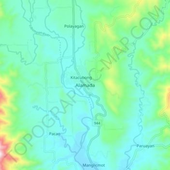
Name: Alamada topographic map, elevation, terrain.
Location: Alamada, North Cotabato, Soccsksargen, 9413, Philippines (7.33979 124.51654 7.41979 124.59654)
Average elevation: 200 m
Minimum elevation: 64 m
Maximum elevation: 764 m
Other topographic maps
Click on a map to view its topography, its elevation and its terrain.
Antipas
Temperature ranges from 23 to 32 degrees Celsius, because of its topographic elevation of 320 meters above sea level and proximity to mountainous Bukidnon province, making it one of the cool places in Soccsksargen. The highest temperature is felt during the months of March and April, while the lowest is in…
Average elevation: 297 m