
Make a donation
Bohol topographic map
Click on the map to display elevation.
Make a donation
About this map
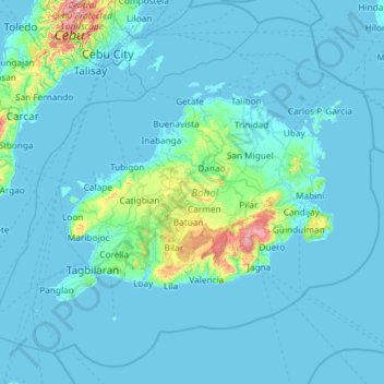
Name: Bohol topographic map, elevation, terrain.
Location: Bohol, Central Visayas, Philippines (9.35076 123.55744 10.38720 124.73522)
Average elevation: 52 m
Minimum elevation: -2 m
Maximum elevation: 897 m
Make a donation
Other topographic maps
Click on a map to view its topography, its elevation and its terrain.
Quezon City
Founded as a pueblo by Saint Pedro Bautista in 1590, San Francisco del Monte may be considered Quezon City's oldest district. The original land area of the old town of San Francisco del Monte was approximately2.5 square kilometres (1.0 sq mi) and covered parts of what is currently known as Project 7 and 8 and…
Average elevation: 57 m
Cabadbaran
Philippines > Agusan del Norte
It is 29 kilometres (18 mi) from Butuan. It is generally flat with rolling hills and swamplands in its western part. The highest of all mountains in the Caraga region, Mount Hilong-Hilong (with an altitude of 2,012 metres (6,601 ft) above sea level), rises in this city.
Average elevation: 179 m
Baguio
In 1903, Filipinos, Japanese and Chinese workers were hired to build Kennon Road, the first road directly connecting Baguio with the lowlands of La Union and Pangasinan. Before this, the only road to Benguet was Naguilian Road, and it was largely a horse trail at higher elevations. Camp John Hay was…
Average elevation: 881 m
Make a donation
Make a donation
Bacolod
Bacólod (English: Bacolod), is derived from bakólod (Old Spelling: bacólod), the Old Hiligaynon (Old Ilonggo) (Old Spelling: Ylongo and Ilongo) word for a "hill, turtle, mound, rise, hillock, down, any small eminence or elevation", since the resettlement was founded on a stony, hilly area, now the barangay…
Average elevation: 49 m
Didicas Volcano
Philippines > Cagayan > Calayan
Didicas is topped with a lava dome with an elevation of 228 metres (748 ft) and a base diameter of 1,200 metres (3,900 ft) at sea level. It is at the southern end of the Luzon Volcanic Arc, and like all the volcanoes in the Philippines, is part of the Pacific ring of fire.
Average elevation: 7 m
Calapan
Philippines > Oriental Mindoro
The overall land characteristic is a wide plain with rivers, interspersed with wetlands at the seacoast periphery. The highest elevation is 187 m (614 ft) above sea level at Bulusan Hill, a 6-kilometre (3.7 mi) long landform east of the city, which interrupts the mostly flat terrain north-east of the…
Average elevation: 40 m
Make a donation
Naguilian
The approximate elevation of the municipality is 165 meters above sea level. It has the ninth highest approximate average elevation among the twenty (20) towns of the province. The portion with the highest elevation is 544 meters above sea level while the lowest is 10 meters. The slopes range from 2–7% in…
Average elevation: 85 m
Malolos
Malolos is relatively flat of about 0.81% to a gently sloping of 2.17%. The slope of the land descends towards west, southwest to southern direction. The highest land elevation is at about 6.0 meters above sea level while the lowest is only half a meter below sea level. A network of natural waterways and…
Average elevation: 6 m
Make a donation
Valencia
The city's topography is characterized as flat to undulating hills with extensive plateaus and mountainous areas and cliffs on both eastern and western portions bounding the municipality of San Fernando on the east and the municipality of Talakag on the west. Its highest point is Mount Kalatungan in the…
Average elevation: 566 m
Make a donation
Dasmariñas
Dasmariñas is partly lowland and partly hilly. The Poblacion itself is elevated. From an elevation of 80 meters (260 ft) at the Poblacion, the land rises to 250 meters (820 ft) towards Silang. Generally, land near rivers and creeks are rugged. Dasmariñas is outside the typhoon belt and has no fault line…
Average elevation: 97 m
Make a donation
Legazpi
Legazpi's topography is generally plain on the northeastern areas, with slopes ranging from five to fifteen degrees. The southern areas have mostly rolling to hilly terrain. In the city's coastal areas, the terrain varies from plain (north) to hilly (south). Legazpi is criss-crossed by several rivers including…
Average elevation: 150 m
Make a donation
Tagum
One of the significant accomplishments of the officialdom of Tagum during the 1990s was its elevation from a second to the first-class municipality. This opened a gateway to increase its financial resources through the Internal Revenue Allocation (IRA) from the national government and local revenues. This was…
Average elevation: 103 m
Make a donation
Tagaytay
The southern and eastern portions of Tagaytay are covered by hills and mountains which is generally forests, pine trees and open grasslands. The city lies along Tagaytay Ridge, a ridge stretching about 32 kilometres (20 mi) from Mount Batulao in the west to Mount Sungay in the east with elevations averaging…
Average elevation: 229 m
Make a donation
Cabangan
The municipality has a varied topography characterized by high mountains to narrow coastal plains. The most outstanding feature observable in the municipality is the Zambales Range.
Average elevation: 52 m
Make a donation
Make a donation
Tabaco
The City of Tabaco is located on the eastern coast of Albay province with an area of 117.14 km2 (45.23 sq mi). The terrain in the poblacion or town center of Tabaco is generally flat with the highest elevation at around 5 m (16 ft). The northwestern portion reaches 400 m (1,300 ft) above sea level. The city's…
Average elevation: 182 m
Make a donation
Montalban
Philippines > Rizal > Rodriguez
Rodriguez is generally very rough in topography, with 83% of its total land area composed of upland areas, hills and mountain ranges. The remaining 17% low-lying terrain and rolling lands are found at the south-western portion of the municipality, along with the northern portions of the Municipality of San…
Average elevation: 99 m
Make a donation
San Juan
"San Juan" is a contraction of the city's traditional name of "San Juan del Monte" (lit. 'Saint John of the Mountain'). As with numerous other places in the Philippines, the name combines a patron saint and a toponym; in this case Saint John the Baptist with the locale's hilly terrain and relatively higher…
Average elevation: 35 m
Make a donation
Make a donation
Make a donation
Make a donation
Make a donation
Make a donation
Make a donation
Make a donation
Make a donation
Make a donation
Make a donation
Make a donation