
Make a donation
Espírito Santo topographic map
Click on the map to display elevation.
Make a donation
Espírito Santo
The Captaincy of Espírito Santo was carved out of the Captaincy of Bahia in the 18th century, during the colonial rule of Brazil, and named after a 16th-century captaincy covering roughly the same area of coast. Following the elevation of Brazil to a constituent kingdom of United Kingdom of Portugal, Brazil and the Algarves in 1815, prompted by the transfer of the Portuguese Court to Brazil, Espírito Santo was elevated to a province. After the independence of Brazil in 1822, it became a province of the newly established Empire of Brazil, and after Brazil became a republic in 1889, it was granted statehood. In the early 20th century, its current state symbols were adopted.
Make a donation
About this map
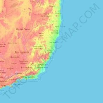
Name: Espírito Santo topographic map, elevation, terrain.
Location: Espírito Santo, Southeast Region, Brazil (-21.43393 -41.87981 -17.89195 -28.62896)
Average elevation: 265 m
Minimum elevation: -1 m
Maximum elevation: 2,500 m
Make a donation
Other topographic maps
Click on a map to view its topography, its elevation and its terrain.
São José do Rio Preto
Brazil > São Paulo > Região Metropolitana de São José do Rio Preto
Average elevation: 524 m
Make a donation
Itamarati
Brazil > Minas Gerais > Região Metropolitana de Belo Horizonte > Belo Horizonte
Average elevation: 831 m
São Paulo
Brazil > São Paulo > Região Metropolitana de São Paulo > São Paulo
São Paulo is in Southeastern Brazil, in southeastern São Paulo State, approximately halfway between Curitiba and Rio de Janeiro. The city is on a plateau placed beyond the Serra do Mar (Portuguese for "Sea Range" or "Coastal Range"), itself a component of the vast region known as the Brazilian Highlands,…
Average elevation: 785 m
Make a donation